You are here: Home > Network List > TA - USArray Transportable Network (new EarthScope stations) Stations List
> Station Y53A Monroe, GA, USA > Earthquake Result Viewer
Y53A Monroe, GA, USA - Earthquake Result Viewer
| Earthquake location: |
Peru-Bolivia Border Region |
| Earthquake latitude/longitude: |
-17.7/-69.6 |
| Earthquake time(UTC): |
2012/05/14 (135) 10:00:40 GMT |
| Earthquake Depth: |
106 km |
| Earthquake Magnitude: |
6.4 MB, 6.2 MW, 6.2 MW |
| Earthquake Catalog/Contributor: |
WHDF/NEIC |
|
| Network: |
TA USArray Transportable Network (new EarthScope stations) |
| Station: |
Y53A Monroe, GA, USA |
| Lat/Lon: |
33.86 N/83.58 W |
| Elevation: |
234 m |
|
| Distance: |
53.0 deg |
| Az: |
345.398 deg |
| Baz: |
163.213 deg |
| Ray Param: |
0.06608038 |
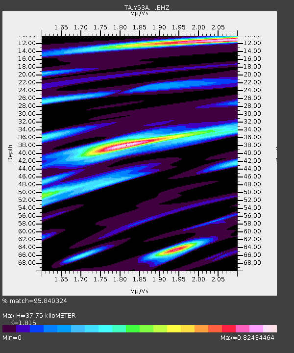
| Estimated Moho Depth: |
37.75 km |
| Estimated Crust Vp/Vs: |
1.82 |
| Assumed Crust Vp: |
6.565 km/s |
| Estimated Crust Vs: |
3.617 km/s |
| Estimated Crust Poisson's Ratio: |
0.28 |
|
| Radial Match: |
95.840324 % |
| Radial Bump: |
338 |
| Transverse Match: |
82.125175 % |
| Transverse Bump: |
400 |
| SOD ConfigId: |
446234 |
| Insert Time: |
2012-08-08 22:53:23.699 +0000 |
| GWidth: |
2.5 |
| Max Bumps: |
400 |
| Tol: |
0.001 |
|

Signal To Noise
| Channel | StoN | STA | LTA |
| TA:Y53A: :BHZ:20120514T10:09:15.175007Z | 39.46202 | 3.5677547E-6 | 9.040983E-8 |
| TA:Y53A: :BHN:20120514T10:09:15.175007Z | 28.93217 | 1.9533697E-6 | 6.7515494E-8 |
| TA:Y53A: :BHE:20120514T10:09:15.175007Z | 8.186767 | 6.492101E-7 | 7.9299944E-8 |
| Arrivals |
| Ps | 5.0 SECOND |
| PpPs | 15 SECOND |
| PsPs/PpSs | 20 SECOND |


