You are here: Home > Network List > G - GEOSCOPE Stations List
> Station NOUC Port Laguerre, New Caledonia > Earthquake Result Viewer
NOUC Port Laguerre, New Caledonia - Earthquake Result Viewer

| Earthquake location: |
Northern Molucca Sea |
| Earthquake latitude/longitude: |
2.6/127.7 |
| Earthquake time(UTC): |
1995/07/26 (207) 23:42:02 GMT |
| Earthquake Depth: |
66 km |
| Earthquake Magnitude: |
5.9 MB, 6.4 UNKNOWN, 6.4 MW |
| Earthquake Catalog/Contributor: |
WHDF/NEIC |
|
| Network: |
G GEOSCOPE |
| Station: |
NOUC Port Laguerre, New Caledonia |
| Lat/Lon: |
22.10 S/166.30 E |
| Elevation: |
112 m |
|
| Distance: |
45.0 deg |
| Az: |
125.044 deg |
| Baz: |
298.123 deg |
| Ray Param: |
0.0713742 |
| Estimated Moho Depth: |
11.75 km |
| Estimated Crust Vp/Vs: |
1.62 |
| Assumed Crust Vp: |
5.14 km/s |
| Estimated Crust Vs: |
3.178 km/s |
| Estimated Crust Poisson's Ratio: |
0.19 |
|
| Radial Match: |
82.53699 % |
| Radial Bump: |
400 |
| Transverse Match: |
75.83694 % |
| Transverse Bump: |
400 |
| SOD ConfigId: |
6273 |
| Insert Time: |
2010-02-26 23:36:35.277 +0000 |
| GWidth: |
2.5 |
| Max Bumps: |
400 |
| Tol: |
0.001 |
|
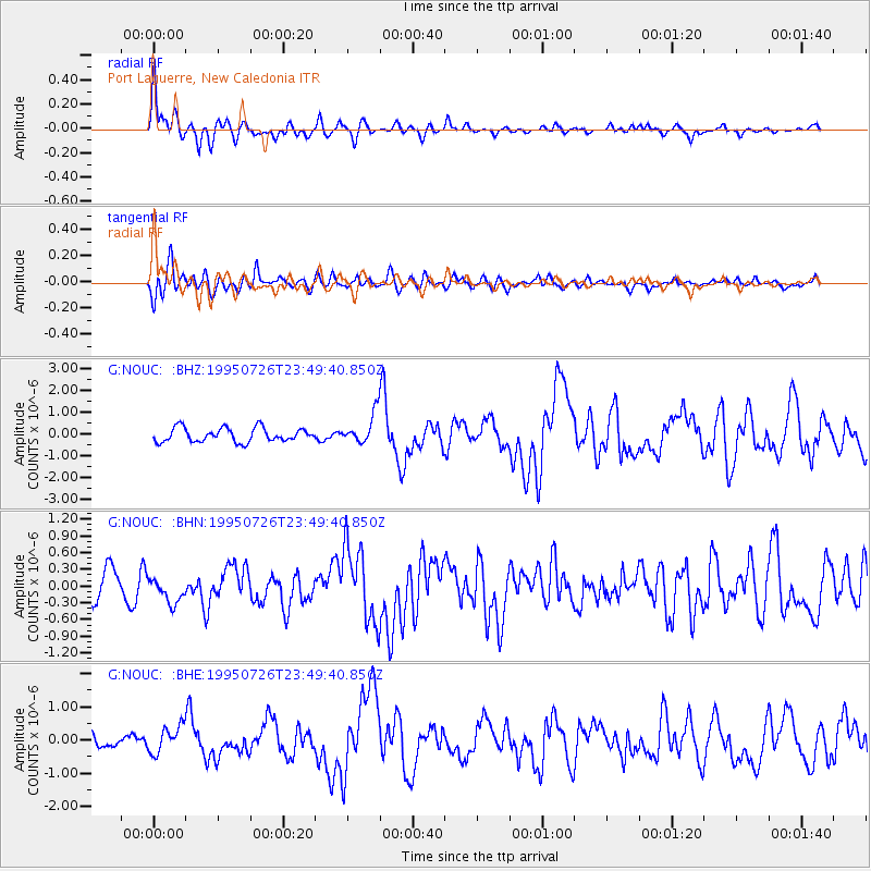
Signal To Noise
| Channel | StoN | STA | LTA |
| G:NOUC: :BHN:19950726T23:49:40.850Z | 0.9599451 | 2.358277E-7 | 2.456679E-7 |
| G:NOUC: :BHE:19950726T23:49:40.850Z | 1.868247 | 4.0606506E-7 | 2.1735084E-7 |
| G:NOUC: :BHZ:19950726T23:49:40.850Z | 2.1510851 | 6.8736574E-7 | 3.1954374E-7 |
| Arrivals |
| Ps | 1.5 SECOND |
| PpPs | 5.7 SECOND |
| PsPs/PpSs | 7.2 SECOND |


