You are here: Home > Network List > G - GEOSCOPE Stations List
> Station NOUC Port Laguerre, New Caledonia > Earthquake Result Viewer
NOUC Port Laguerre, New Caledonia - Earthquake Result Viewer
| Earthquake location: |
Mariana Islands |
| Earthquake latitude/longitude: |
18.9/145.2 |
| Earthquake time(UTC): |
1995/08/23 (235) 07:06:02 GMT |
| Earthquake Depth: |
596 km |
| Earthquake Magnitude: |
6.3 MB, 6.3 UNKNOWN, 7.0 MW |
| Earthquake Catalog/Contributor: |
WHDF/NEIC |
|
| Network: |
G GEOSCOPE |
| Station: |
NOUC Port Laguerre, New Caledonia |
| Lat/Lon: |
22.10 S/166.30 E |
| Elevation: |
112 m |
|
| Distance: |
45.6 deg |
| Az: |
152.143 deg |
| Baz: |
331.501 deg |
| Ray Param: |
0.068200365 |
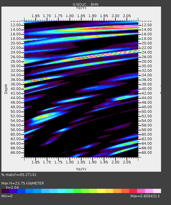
| Estimated Moho Depth: |
23.75 km |
| Estimated Crust Vp/Vs: |
2.04 |
| Assumed Crust Vp: |
5.14 km/s |
| Estimated Crust Vs: |
2.52 km/s |
| Estimated Crust Poisson's Ratio: |
0.34 |
|
| Radial Match: |
85.27101 % |
| Radial Bump: |
400 |
| Transverse Match: |
78.63227 % |
| Transverse Bump: |
400 |
| SOD ConfigId: |
6273 |
| Insert Time: |
2010-02-26 23:36:36.437 +0000 |
| GWidth: |
2.5 |
| Max Bumps: |
400 |
| Tol: |
0.001 |
|
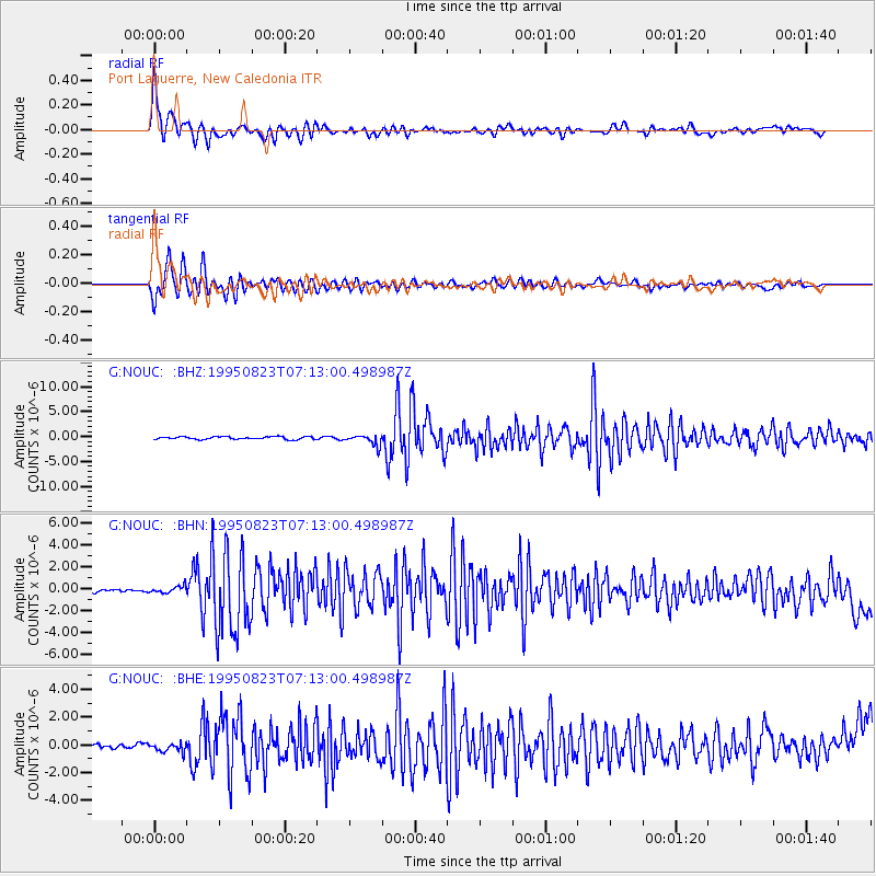
Signal To Noise
| Channel | StoN | STA | LTA |
| G:NOUC: :BHN:19950823T07:13:00.498987Z | 1.3821732 | 2.9975678E-7 | 2.1687353E-7 |
| G:NOUC: :BHE:19950823T07:13:00.498987Z | 1.6916586 | 3.4014482E-7 | 2.0107178E-7 |
| G:NOUC: :BHZ:19950823T07:13:00.498987Z | 4.0159264 | 1.067254E-6 | 2.6575538E-7 |
| Arrivals |
| Ps | 5.0 SECOND |
| PpPs | 14 SECOND |
| PsPs/PpSs | 19 SECOND |


