You are here: Home > Network List > TA - USArray Transportable Network (new EarthScope stations) Stations List
> Station O03E Paynes Creek, CA, USA > Earthquake Result Viewer
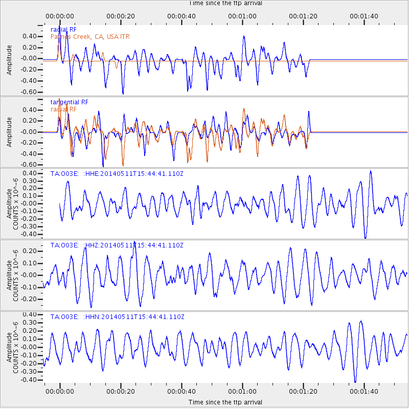
O03E Paynes Creek, CA, USA - Earthquake Result Viewer
*The percent match for this event was below the threshold and hence no stack was calculated.
| Earthquake location: |
Solomon Islands |
| Earthquake latitude/longitude: |
-6.6/155.0 |
| Earthquake time(UTC): |
2014/05/11 (131) 15:32:22 GMT |
| Earthquake Depth: |
50 km |
| Earthquake Magnitude: |
5.2 MW |
| Earthquake Catalog/Contributor: |
ISC/ISC |
|
| Network: |
TA USArray Transportable Network (new EarthScope stations) |
| Station: |
O03E Paynes Creek, CA, USA |
| Lat/Lon: |
40.29 N/121.80 W |
| Elevation: |
967 m |
|
| Distance: |
89.0 deg |
| Az: |
49.423 deg |
| Baz: |
260.606 deg |
| Ray Param: |
$rayparam |
*The percent match for this event was below the threshold and hence was not used in the summary stack. |
|
| Radial Match: |
54.7289 % |
| Radial Bump: |
400 |
| Transverse Match: |
64.47242 % |
| Transverse Bump: |
400 |
| SOD ConfigId: |
3390531 |
| Insert Time: |
2019-04-11 19:55:19.992 +0000 |
| GWidth: |
2.5 |
| Max Bumps: |
400 |
| Tol: |
0.001 |
|
Signal To Noise
| Channel | StoN | STA | LTA |
| TA:O03E: :HHZ:20140511T15:44:41.110Z | 0.84231156 | 7.665338E-8 | 9.10036E-8 |
| TA:O03E: :HHN:20140511T15:44:41.110Z | 1.1347774 | 1.361634E-7 | 1.1999127E-7 |
| TA:O03E: :HHE:20140511T15:44:41.110Z | 0.8963947 | 1.08706956E-7 | 1.212713E-7 |
| Arrivals |
| Ps | |
| PpPs | |
| PsPs/PpSs | |


