You are here: Home > Network List > G - GEOSCOPE Stations List
> Station NOUC Port Laguerre, New Caledonia > Earthquake Result Viewer
NOUC Port Laguerre, New Caledonia - Earthquake Result Viewer
| Earthquake location: |
Mariana Islands |
| Earthquake latitude/longitude: |
17.4/145.5 |
| Earthquake time(UTC): |
1996/06/09 (161) 01:12:16 GMT |
| Earthquake Depth: |
149 km |
| Earthquake Magnitude: |
6.0 MB, 5.9 MS, 6.5 UNKNOWN, 6.5 MW |
| Earthquake Catalog/Contributor: |
WHDF/NEIC |
|
| Network: |
G GEOSCOPE |
| Station: |
NOUC Port Laguerre, New Caledonia |
| Lat/Lon: |
22.10 S/166.30 E |
| Elevation: |
112 m |
|
| Distance: |
44.3 deg |
| Az: |
151.794 deg |
| Baz: |
330.89 deg |
| Ray Param: |
0.07147067 |
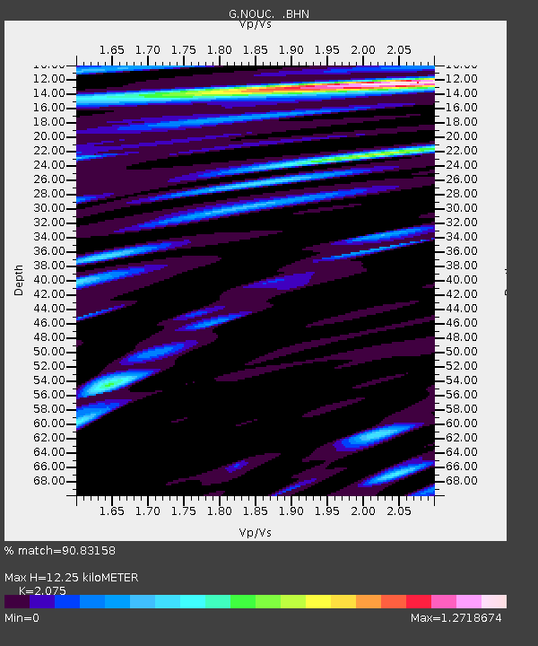
| Estimated Moho Depth: |
12.25 km |
| Estimated Crust Vp/Vs: |
2.08 |
| Assumed Crust Vp: |
5.14 km/s |
| Estimated Crust Vs: |
2.477 km/s |
| Estimated Crust Poisson's Ratio: |
0.35 |
|
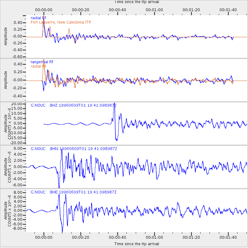
| Radial Match: |
90.83158 % |
| Radial Bump: |
400 |
| Transverse Match: |
84.972145 % |
| Transverse Bump: |
400 |
| SOD ConfigId: |
6273 |
| Insert Time: |
2010-02-26 23:36:39.312 +0000 |
| GWidth: |
2.5 |
| Max Bumps: |
400 |
| Tol: |
0.001 |
|
Signal To Noise
| Channel | StoN | STA | LTA |
| G:NOUC: :BHN:19960609T01:19:41.098987Z | 1.1608039 | 2.6148706E-7 | 2.2526376E-7 |
| G:NOUC: :BHE:19960609T01:19:41.098987Z | 0.63452965 | 2.957315E-7 | 4.660641E-7 |
| G:NOUC: :BHZ:19960609T01:19:41.098987Z | 1.3559837 | 8.1617486E-7 | 6.019061E-7 |
| Arrivals |
| Ps | 2.7 SECOND |
| PpPs | 7.1 SECOND |
| PsPs/PpSs | 9.7 SECOND |


