You are here: Home > Network List > CI - Caltech Regional Seismic Network Stations List
> Station LGU LGU, Camarillo, CA, USA > Earthquake Result Viewer
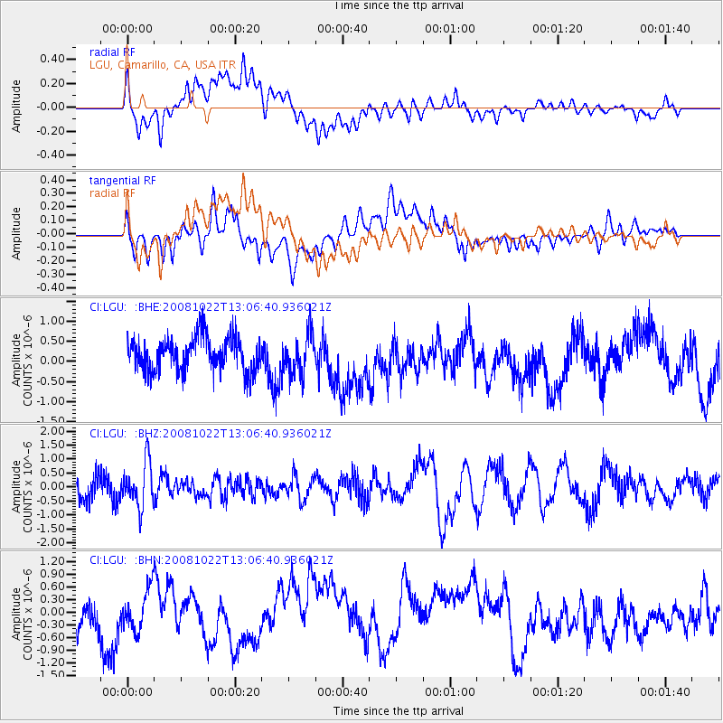
LGU LGU, Camarillo, CA, USA - Earthquake Result Viewer
*The percent match for this event was below the threshold and hence no stack was calculated.
| Earthquake location: |
Tonga Islands |
| Earthquake latitude/longitude: |
-18.4/-175.4 |
| Earthquake time(UTC): |
2008/10/22 (296) 12:55:57 GMT |
| Earthquake Depth: |
233 km |
| Earthquake Magnitude: |
5.9 MB, 6.4 MW, 6.3 MW |
| Earthquake Catalog/Contributor: |
WHDF/NEIC |
|
| Network: |
CI Caltech Regional Seismic Network |
| Station: |
LGU LGU, Camarillo, CA, USA |
| Lat/Lon: |
34.11 N/119.07 W |
| Elevation: |
416 m |
|
| Distance: |
74.8 deg |
| Az: |
45.656 deg |
| Baz: |
234.918 deg |
| Ray Param: |
$rayparam |
*The percent match for this event was below the threshold and hence was not used in the summary stack. |
|
| Radial Match: |
37.616505 % |
| Radial Bump: |
400 |
| Transverse Match: |
38.60303 % |
| Transverse Bump: |
400 |
| SOD ConfigId: |
2560 |
| Insert Time: |
2010-02-25 20:21:39.751 +0000 |
| GWidth: |
2.5 |
| Max Bumps: |
400 |
| Tol: |
0.001 |
|
Signal To Noise
| Channel | StoN | STA | LTA |
| CI:LGU: :BHZ:20081022T13:06:40.936021Z | 2.616878 | 8.065416E-7 | 3.0820758E-7 |
| CI:LGU: :BHN:20081022T13:06:40.936021Z | 1.2211798 | 4.797882E-7 | 3.9288904E-7 |
| CI:LGU: :BHE:20081022T13:06:40.936021Z | 1.177478 | 4.9374125E-7 | 4.19321E-7 |
| Arrivals |
| Ps | |
| PpPs | |
| PsPs/PpSs | |


