You are here: Home > Network List > G - GEOSCOPE Stations List
> Station NOUC Port Laguerre, New Caledonia > Earthquake Result Viewer
NOUC Port Laguerre, New Caledonia - Earthquake Result Viewer
| Earthquake location: |
Xizang |
| Earthquake latitude/longitude: |
35.1/87.3 |
| Earthquake time(UTC): |
1997/11/08 (312) 10:02:52 GMT |
| Earthquake Depth: |
33 km |
| Earthquake Magnitude: |
6.2 MB, 7.9 MS, 7.7 UNKNOWN, 7.6 MW |
| Earthquake Catalog/Contributor: |
WHDF/NEIC |
|
| Network: |
G GEOSCOPE |
| Station: |
NOUC Port Laguerre, New Caledonia |
| Lat/Lon: |
22.10 S/166.30 E |
| Elevation: |
112 m |
|
| Distance: |
93.9 deg |
| Az: |
114.156 deg |
| Baz: |
306.193 deg |
| Ray Param: |
0.041148864 |
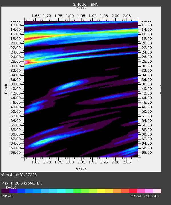
| Estimated Moho Depth: |
28.0 km |
| Estimated Crust Vp/Vs: |
1.60 |
| Assumed Crust Vp: |
5.14 km/s |
| Estimated Crust Vs: |
3.212 km/s |
| Estimated Crust Poisson's Ratio: |
0.18 |
|
| Radial Match: |
81.27348 % |
| Radial Bump: |
336 |
| Transverse Match: |
71.62486 % |
| Transverse Bump: |
285 |
| SOD ConfigId: |
6273 |
| Insert Time: |
2010-02-26 23:36:45.799 +0000 |
| GWidth: |
2.5 |
| Max Bumps: |
400 |
| Tol: |
0.001 |
|
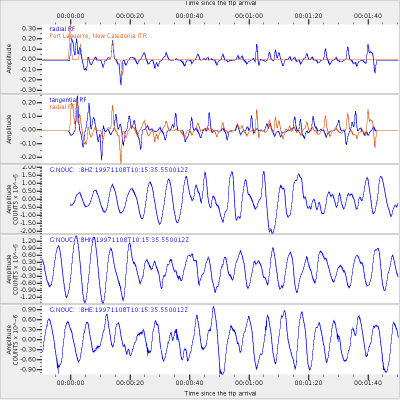
Signal To Noise
| Channel | StoN | STA | LTA |
| G:NOUC: :BHN:19971108T10:15:35.550012Z | 3.6090133 | 9.669042E-7 | 2.6791372E-7 |
| G:NOUC: :BHE:19971108T10:15:35.550012Z | 1.069131 | 3.9674438E-7 | 3.7109052E-7 |
| G:NOUC: :BHZ:19971108T10:15:35.550012Z | 1.8441073 | 9.744334E-7 | 5.2840386E-7 |
| Arrivals |
| Ps | 3.3 SECOND |
| PpPs | 14 SECOND |
| PsPs/PpSs | 17 SECOND |


