You are here: Home > Network List > G - GEOSCOPE Stations List
> Station NOUC Port Laguerre, New Caledonia > Earthquake Result Viewer
NOUC Port Laguerre, New Caledonia - Earthquake Result Viewer
| Earthquake location: |
Hokkaido, Japan Region |
| Earthquake latitude/longitude: |
43.7/146.0 |
| Earthquake time(UTC): |
1994/08/31 (243) 09:07:26 GMT |
| Earthquake Depth: |
80 km |
| Earthquake Magnitude: |
5.9 MB, 6.2 UNKNOWN, 6.2 MW |
| Earthquake Catalog/Contributor: |
WHDF/NEIC |
|
| Network: |
G GEOSCOPE |
| Station: |
NOUC Port Laguerre, New Caledonia |
| Lat/Lon: |
22.10 S/166.30 E |
| Elevation: |
112 m |
|
| Distance: |
68.1 deg |
| Az: |
159.694 deg |
| Baz: |
344.252 deg |
| Ray Param: |
0.0563437 |
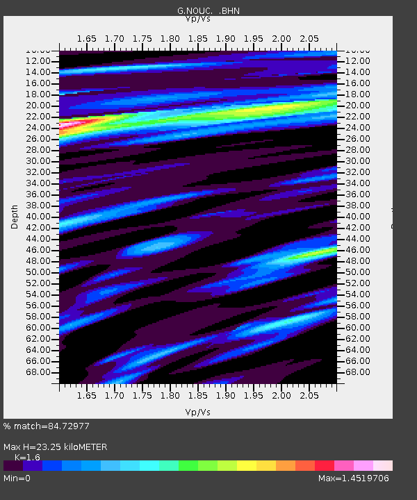
| Estimated Moho Depth: |
23.25 km |
| Estimated Crust Vp/Vs: |
1.60 |
| Assumed Crust Vp: |
5.14 km/s |
| Estimated Crust Vs: |
3.212 km/s |
| Estimated Crust Poisson's Ratio: |
0.18 |
|
| Radial Match: |
84.72977 % |
| Radial Bump: |
400 |
| Transverse Match: |
77.19468 % |
| Transverse Bump: |
400 |
| SOD ConfigId: |
4480 |
| Insert Time: |
2010-02-26 23:36:48.482 +0000 |
| GWidth: |
2.5 |
| Max Bumps: |
400 |
| Tol: |
0.001 |
|
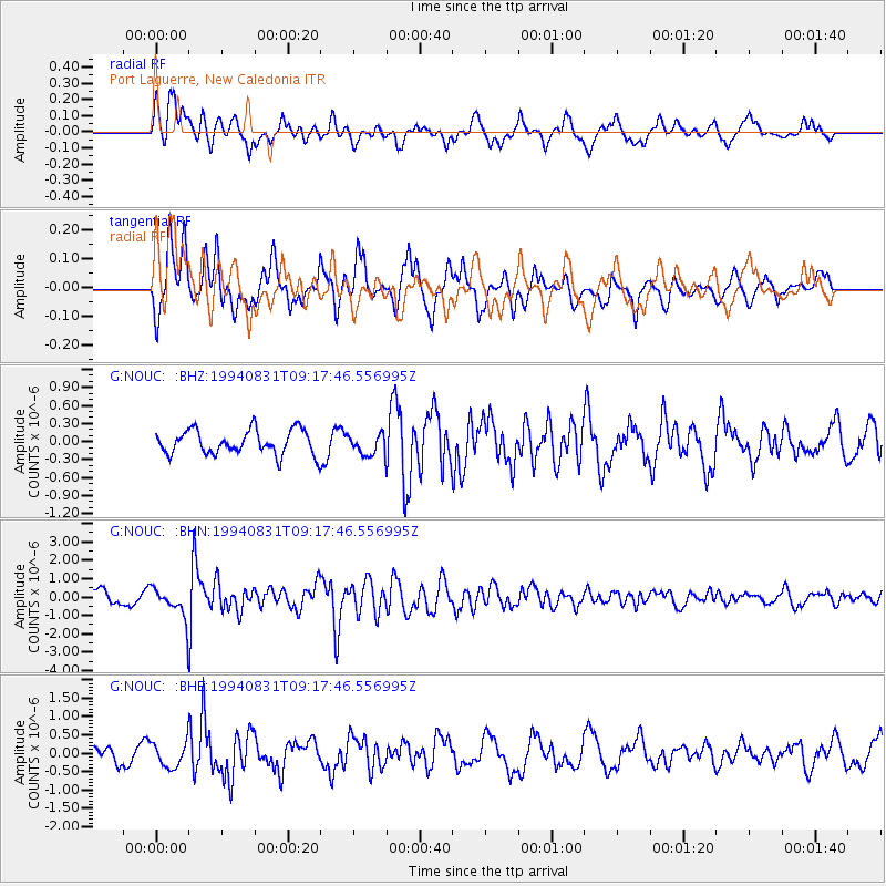
Signal To Noise
| Channel | StoN | STA | LTA |
| G:NOUC: :BHN:19940831T09:17:46.556995Z | 2.8030794 | 8.485067E-7 | 3.0270522E-7 |
| G:NOUC: :BHE:19940831T09:17:46.556995Z | 1.4887965 | 3.4146845E-7 | 2.2935872E-7 |
| G:NOUC: :BHZ:19940831T09:17:46.556995Z | 0.854091 | 1.7198059E-7 | 2.0136098E-7 |
| Arrivals |
| Ps | 2.8 SECOND |
| PpPs | 11 SECOND |
| PsPs/PpSs | 14 SECOND |


