You are here: Home > Network List > G - GEOSCOPE Stations List
> Station NOUC Port Laguerre, New Caledonia > Earthquake Result Viewer
NOUC Port Laguerre, New Caledonia - Earthquake Result Viewer

| Earthquake location: |
Irian Jaya, Indonesia |
| Earthquake latitude/longitude: |
-2.7/138.9 |
| Earthquake time(UTC): |
1998/07/29 (210) 18:00:29 GMT |
| Earthquake Depth: |
33 km |
| Earthquake Magnitude: |
5.9 MB, 6.7 MS, 6.6 UNKNOWN, 6.2 ME |
| Earthquake Catalog/Contributor: |
WHDF/NEIC |
|
| Network: |
G GEOSCOPE |
| Station: |
NOUC Port Laguerre, New Caledonia |
| Lat/Lon: |
22.10 S/166.30 E |
| Elevation: |
112 m |
|
| Distance: |
32.9 deg |
| Az: |
128.148 deg |
| Baz: |
302.106 deg |
| Ray Param: |
0.078416266 |
| Estimated Moho Depth: |
28.5 km |
| Estimated Crust Vp/Vs: |
1.60 |
| Assumed Crust Vp: |
5.14 km/s |
| Estimated Crust Vs: |
3.212 km/s |
| Estimated Crust Poisson's Ratio: |
0.18 |
|
| Radial Match: |
86.4669 % |
| Radial Bump: |
249 |
| Transverse Match: |
76.80457 % |
| Transverse Bump: |
394 |
| SOD ConfigId: |
4480 |
| Insert Time: |
2010-02-26 23:36:52.814 +0000 |
| GWidth: |
2.5 |
| Max Bumps: |
400 |
| Tol: |
0.001 |
|
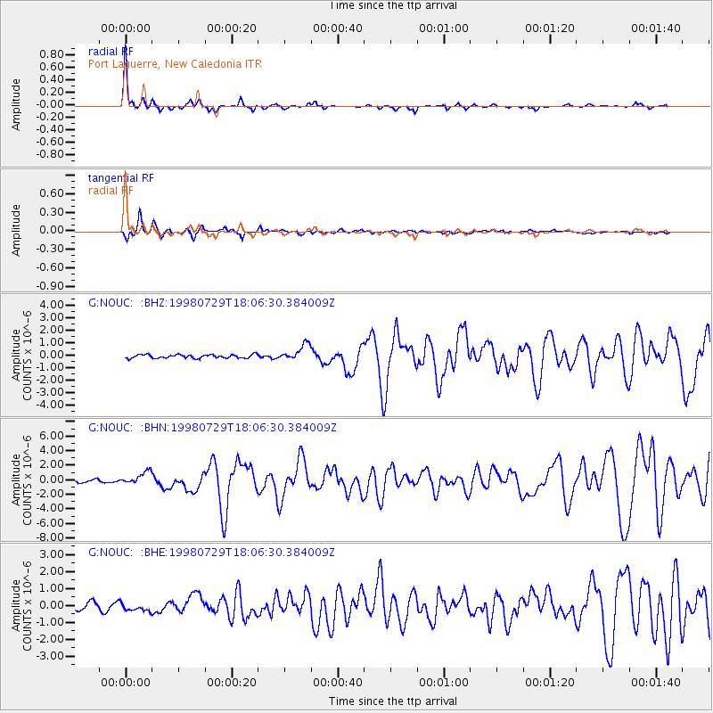
Signal To Noise
| Channel | StoN | STA | LTA |
| G:NOUC: :BHN:19980729T18:06:30.384009Z | 4.987534 | 8.925814E-7 | 1.7896247E-7 |
| G:NOUC: :BHE:19980729T18:06:30.384009Z | 1.2729222 | 2.1286192E-7 | 1.6722305E-7 |
| G:NOUC: :BHZ:19980729T18:06:30.384009Z | 4.6068435 | 6.3962113E-7 | 1.3884151E-7 |
| Arrivals |
| Ps | 3.5 SECOND |
| PpPs | 14 SECOND |
| PsPs/PpSs | 17 SECOND |


