You are here: Home > Network List > G - GEOSCOPE Stations List
> Station NOUC Port Laguerre, New Caledonia > Earthquake Result Viewer
NOUC Port Laguerre, New Caledonia - Earthquake Result Viewer
| Earthquake location: |
Northern Molucca Sea |
| Earthquake latitude/longitude: |
0.8/126.0 |
| Earthquake time(UTC): |
1998/10/28 (301) 16:25:03 GMT |
| Earthquake Depth: |
33 km |
| Earthquake Magnitude: |
6.2 MB, 6.2 MS, 6.6 UNKNOWN, 6.6 MW |
| Earthquake Catalog/Contributor: |
WHDF/NEIC |
|
| Network: |
G GEOSCOPE |
| Station: |
NOUC Port Laguerre, New Caledonia |
| Lat/Lon: |
22.10 S/166.30 E |
| Elevation: |
112 m |
|
| Distance: |
45.5 deg |
| Az: |
122.628 deg |
| Baz: |
294.767 deg |
| Ray Param: |
0.07119521 |
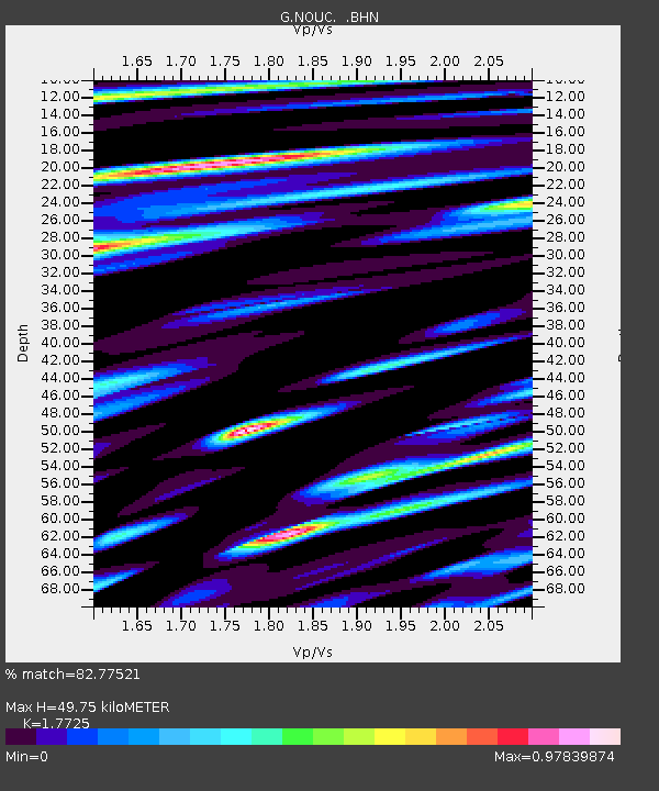
| Estimated Moho Depth: |
49.75 km |
| Estimated Crust Vp/Vs: |
1.77 |
| Assumed Crust Vp: |
5.14 km/s |
| Estimated Crust Vs: |
2.9 km/s |
| Estimated Crust Poisson's Ratio: |
0.27 |
|
| Radial Match: |
82.77521 % |
| Radial Bump: |
350 |
| Transverse Match: |
79.11272 % |
| Transverse Bump: |
400 |
| SOD ConfigId: |
4480 |
| Insert Time: |
2010-02-26 23:36:58.731 +0000 |
| GWidth: |
2.5 |
| Max Bumps: |
400 |
| Tol: |
0.001 |
|
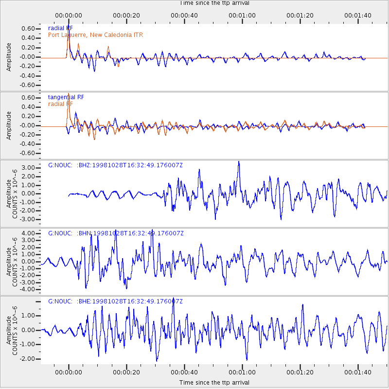
Signal To Noise
| Channel | StoN | STA | LTA |
| G:NOUC: :BHN:19981028T16:32:49.176007Z | 6.070366 | 9.3583907E-7 | 1.5416518E-7 |
| G:NOUC: :BHE:19981028T16:32:49.176007Z | 1.141243 | 2.42502E-7 | 2.1248937E-7 |
| G:NOUC: :BHZ:19981028T16:32:49.176007Z | 1.899228 | 4.881505E-7 | 2.5702573E-7 |
| Arrivals |
| Ps | 7.8 SECOND |
| PpPs | 26 SECOND |
| PsPs/PpSs | 34 SECOND |


