You are here: Home > Network List > G - GEOSCOPE Stations List
> Station NOUC Port Laguerre, New Caledonia > Earthquake Result Viewer
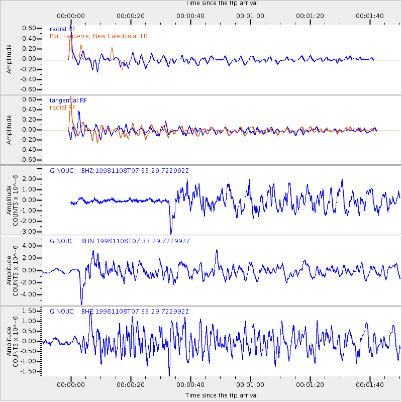
NOUC Port Laguerre, New Caledonia - Earthquake Result Viewer

| Earthquake location: |
Savu Sea |
| Earthquake latitude/longitude: |
-9.1/121.4 |
| Earthquake time(UTC): |
1998/11/08 (312) 07:25:48 GMT |
| Earthquake Depth: |
33 km |
| Earthquake Magnitude: |
6.0 MB, 5.9 MS, 6.4 UNKNOWN, 5.7 ME |
| Earthquake Catalog/Contributor: |
WHDF/NEIC |
|
| Network: |
G GEOSCOPE |
| Station: |
NOUC Port Laguerre, New Caledonia |
| Lat/Lon: |
22.10 S/166.30 E |
| Elevation: |
112 m |
|
| Distance: |
44.9 deg |
| Az: |
112.101 deg |
| Baz: |
279.409 deg |
| Ray Param: |
0.07154128 |
| Estimated Moho Depth: |
30.0 km |
| Estimated Crust Vp/Vs: |
1.69 |
| Assumed Crust Vp: |
5.14 km/s |
| Estimated Crust Vs: |
3.041 km/s |
| Estimated Crust Poisson's Ratio: |
0.23 |
|
| Radial Match: |
88.75316 % |
| Radial Bump: |
400 |
| Transverse Match: |
79.875275 % |
| Transverse Bump: |
400 |
| SOD ConfigId: |
4480 |
| Insert Time: |
2010-02-26 23:37:00.364 +0000 |
| GWidth: |
2.5 |
| Max Bumps: |
400 |
| Tol: |
0.001 |
|
Signal To Noise
| Channel | StoN | STA | LTA |
| G:NOUC: :BHN:19981108T07:33:29.722992Z | 9.816264 | 1.956226E-6 | 1.9928414E-7 |
| G:NOUC: :BHE:19981108T07:33:29.722992Z | 1.7447728 | 2.1504508E-7 | 1.2325106E-7 |
| G:NOUC: :BHZ:19981108T07:33:29.722992Z | 9.001421 | 1.1664423E-6 | 1.2958425E-7 |
| Arrivals |
| Ps | 4.2 SECOND |
| PpPs | 15 SECOND |
| PsPs/PpSs | 19 SECOND |


