You are here: Home > Network List > UW - Pacific Northwest Regional Seismic Network Stations List
> Station UMAT Pilot Rock, OR, USA > Earthquake Result Viewer
UMAT Pilot Rock, OR, USA - Earthquake Result Viewer
*The percent match for this event was below the threshold and hence no stack was calculated.
| Earthquake location: |
New Britain Region, P.N.G. |
| Earthquake latitude/longitude: |
-5.5/149.7 |
| Earthquake time(UTC): |
2012/05/16 (137) 00:59:32 GMT |
| Earthquake Depth: |
137 km |
| Earthquake Magnitude: |
5.7 MB, 5.7 MW, 5.8 MW |
| Earthquake Catalog/Contributor: |
WHDF/NEIC |
|
| Network: |
UW Pacific Northwest Regional Seismic Network |
| Station: |
UMAT Pilot Rock, OR, USA |
| Lat/Lon: |
45.29 N/118.96 W |
| Elevation: |
1318 m |
|
| Distance: |
94.8 deg |
| Az: |
45.088 deg |
| Baz: |
267.072 deg |
| Ray Param: |
$rayparam |
*The percent match for this event was below the threshold and hence was not used in the summary stack. |
|
| Radial Match: |
48.282368 % |
| Radial Bump: |
373 |
| Transverse Match: |
59.034515 % |
| Transverse Bump: |
363 |
| SOD ConfigId: |
446234 |
| Insert Time: |
2012-08-08 23:21:43.178 +0000 |
| GWidth: |
2.5 |
| Max Bumps: |
400 |
| Tol: |
0.001 |
|
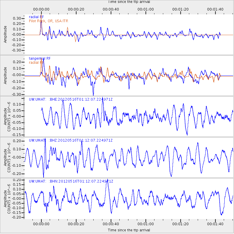
Signal To Noise
| Channel | StoN | STA | LTA |
| UW:UMAT: :BHZ:20120516T01:12:07.224971Z | 1.6404805 | 1.0936846E-7 | 6.666855E-8 |
| UW:UMAT: :BHN:20120516T01:12:07.224971Z | 1.1347556 | 6.614593E-8 | 5.8290897E-8 |
| UW:UMAT: :BHE:20120516T01:12:07.224971Z | 0.7480455 | 4.4740258E-8 | 5.9809544E-8 |
| Arrivals |
| Ps | |
| PpPs | |
| PsPs/PpSs | |


