You are here: Home > Network List > G - GEOSCOPE Stations List
> Station NOUC Port Laguerre, New Caledonia > Earthquake Result Viewer
NOUC Port Laguerre, New Caledonia - Earthquake Result Viewer
| Earthquake location: |
Flores Region, Indonesia |
| Earthquake latitude/longitude: |
-8.9/123.5 |
| Earthquake time(UTC): |
1997/01/17 (017) 11:20:22 GMT |
| Earthquake Depth: |
111 km |
| Earthquake Magnitude: |
6.2 MB, 6.2 UNKNOWN, 6.2 MW |
| Earthquake Catalog/Contributor: |
WHDF/NEIC |
|
| Network: |
G GEOSCOPE |
| Station: |
NOUC Port Laguerre, New Caledonia |
| Lat/Lon: |
22.10 S/166.30 E |
| Elevation: |
112 m |
|
| Distance: |
43.1 deg |
| Az: |
112.824 deg |
| Baz: |
280.872 deg |
| Ray Param: |
0.07237725 |
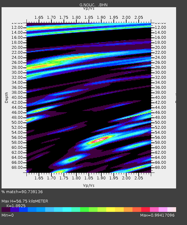
| Estimated Moho Depth: |
56.75 km |
| Estimated Crust Vp/Vs: |
1.89 |
| Assumed Crust Vp: |
5.14 km/s |
| Estimated Crust Vs: |
2.716 km/s |
| Estimated Crust Poisson's Ratio: |
0.31 |
|
| Radial Match: |
90.739136 % |
| Radial Bump: |
400 |
| Transverse Match: |
84.413734 % |
| Transverse Bump: |
400 |
| SOD ConfigId: |
4480 |
| Insert Time: |
2010-02-26 23:37:03.569 +0000 |
| GWidth: |
2.5 |
| Max Bumps: |
400 |
| Tol: |
0.001 |
|
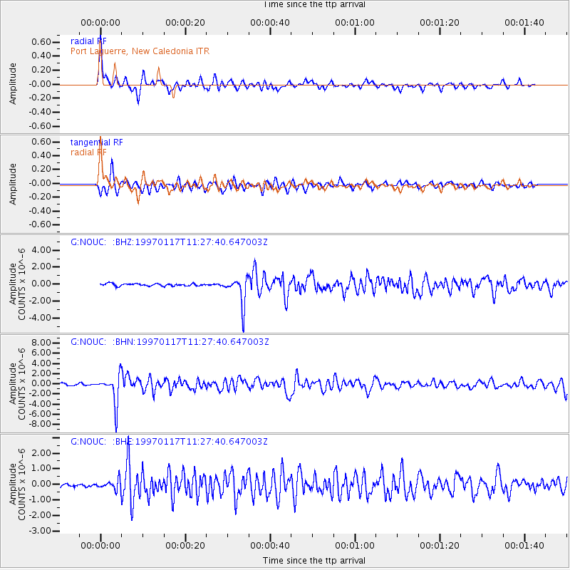
Signal To Noise
| Channel | StoN | STA | LTA |
| G:NOUC: :BHN:19970117T11:27:40.647003Z | 14.961982 | 2.96328E-6 | 1.9805398E-7 |
| G:NOUC: :BHE:19970117T11:27:40.647003Z | 1.8171515 | 3.035252E-7 | 1.6703352E-7 |
| G:NOUC: :BHZ:19970117T11:27:40.647003Z | 12.415788 | 1.6629332E-6 | 1.33937E-7 |
| Arrivals |
| Ps | 10 SECOND |
| PpPs | 31 SECOND |
| PsPs/PpSs | 41 SECOND |


