You are here: Home > Network List > TA - USArray Transportable Network (new EarthScope stations) Stations List
> Station Z47A Carrollton, AL, USA > Earthquake Result Viewer
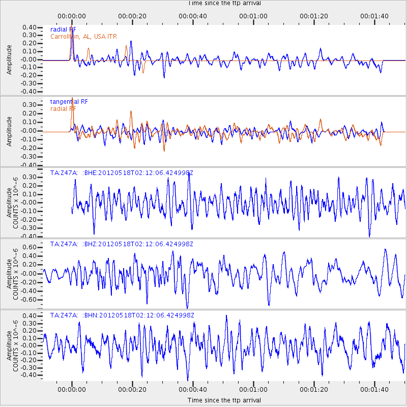
Z47A Carrollton, AL, USA - Earthquake Result Viewer
*The percent match for this event was below the threshold and hence no stack was calculated.
| Earthquake location: |
Off Coast Of Southern Chile |
| Earthquake latitude/longitude: |
-44.8/-80.2 |
| Earthquake time(UTC): |
2012/05/18 (139) 02:00:39 GMT |
| Earthquake Depth: |
10 km |
| Earthquake Magnitude: |
5.5 MB, 5.7 MS, 6.3 MW, 6.3 MW |
| Earthquake Catalog/Contributor: |
WHDF/NEIC |
|
| Network: |
TA USArray Transportable Network (new EarthScope stations) |
| Station: |
Z47A Carrollton, AL, USA |
| Lat/Lon: |
33.20 N/88.07 W |
| Elevation: |
65 m |
|
| Distance: |
78.0 deg |
| Az: |
353.224 deg |
| Baz: |
174.251 deg |
| Ray Param: |
$rayparam |
*The percent match for this event was below the threshold and hence was not used in the summary stack. |
|
| Radial Match: |
69.142815 % |
| Radial Bump: |
400 |
| Transverse Match: |
53.003796 % |
| Transverse Bump: |
400 |
| SOD ConfigId: |
446234 |
| Insert Time: |
2012-08-08 23:31:37.005 +0000 |
| GWidth: |
2.5 |
| Max Bumps: |
400 |
| Tol: |
0.001 |
|
Signal To Noise
| Channel | StoN | STA | LTA |
| TA:Z47A: :BHZ:20120518T02:12:06.424998Z | 2.1551735 | 1.6797372E-7 | 7.7939774E-8 |
| TA:Z47A: :BHN:20120518T02:12:06.424998Z | 1.6151228 | 1.5518441E-7 | 9.608211E-8 |
| TA:Z47A: :BHE:20120518T02:12:06.424998Z | 1.3993449 | 1.5253379E-7 | 1.0900371E-7 |
| Arrivals |
| Ps | |
| PpPs | |
| PsPs/PpSs | |


