You are here: Home > Network List > G - GEOSCOPE Stations List
> Station NOUC Port Laguerre, New Caledonia > Earthquake Result Viewer
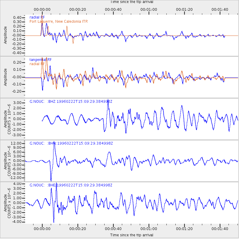
NOUC Port Laguerre, New Caledonia - Earthquake Result Viewer
*The percent match for this event was below the threshold and hence no stack was calculated.
| Earthquake location: |
Kuril Islands |
| Earthquake latitude/longitude: |
45.2/148.6 |
| Earthquake time(UTC): |
1996/02/22 (053) 14:59:09 GMT |
| Earthquake Depth: |
133 km |
| Earthquake Magnitude: |
6.2 MB, 6.3 UNKNOWN, 6.3 MW |
| Earthquake Catalog/Contributor: |
WHDF/NEIC |
|
| Network: |
G GEOSCOPE |
| Station: |
NOUC Port Laguerre, New Caledonia |
| Lat/Lon: |
22.10 S/166.30 E |
| Elevation: |
112 m |
|
| Distance: |
68.9 deg |
| Az: |
162.365 deg |
| Baz: |
346.648 deg |
| Ray Param: |
$rayparam |
*The percent match for this event was below the threshold and hence was not used in the summary stack. |
|
| Radial Match: |
79.02523 % |
| Radial Bump: |
400 |
| Transverse Match: |
76.81139 % |
| Transverse Bump: |
400 |
| SOD ConfigId: |
4480 |
| Insert Time: |
2010-02-26 23:37:09.991 +0000 |
| GWidth: |
2.5 |
| Max Bumps: |
400 |
| Tol: |
0.001 |
|
Signal To Noise
| Channel | StoN | STA | LTA |
| G:NOUC: :BHN:19960222T15:09:29.384998Z | 4.1570315 | 2.6424148E-6 | 6.356494E-7 |
| G:NOUC: :BHE:19960222T15:09:29.384998Z | 1.5532726 | 7.6462396E-7 | 4.922664E-7 |
| G:NOUC: :BHZ:19960222T15:09:29.384998Z | 0.6868576 | 3.9450643E-7 | 5.743642E-7 |
| Arrivals |
| Ps | |
| PpPs | |
| PsPs/PpSs | |


