You are here: Home > Network List > IM - International Miscellaneous Stations Stations List
> Station TX32 TXAR Array, Lajitas, TX, USA > Earthquake Result Viewer
TX32 TXAR Array, Lajitas, TX, USA - Earthquake Result Viewer
| Earthquake location: |
Near Coast Of Northern Chile |
| Earthquake latitude/longitude: |
-25.7/-70.6 |
| Earthquake time(UTC): |
2012/05/19 (140) 08:35:10 GMT |
| Earthquake Depth: |
28 km |
| Earthquake Magnitude: |
5.7 MB, 5.5 MS, 5.8 MW, 5.9 MW |
| Earthquake Catalog/Contributor: |
WHDF/NEIC |
|
| Network: |
IM International Miscellaneous Stations |
| Station: |
TX32 TXAR Array, Lajitas, TX, USA |
| Lat/Lon: |
29.33 N/103.67 W |
| Elevation: |
1013 m |
|
| Distance: |
63.3 deg |
| Az: |
327.735 deg |
| Baz: |
146.534 deg |
| Ray Param: |
0.0596249 |
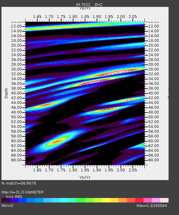
| Estimated Moho Depth: |
31.0 km |
| Estimated Crust Vp/Vs: |
1.99 |
| Assumed Crust Vp: |
6.419 km/s |
| Estimated Crust Vs: |
3.234 km/s |
| Estimated Crust Poisson's Ratio: |
0.33 |
|
| Radial Match: |
86.9878 % |
| Radial Bump: |
400 |
| Transverse Match: |
76.974266 % |
| Transverse Bump: |
400 |
| SOD ConfigId: |
446234 |
| Insert Time: |
2012-08-08 23:50:08.730 +0000 |
| GWidth: |
2.5 |
| Max Bumps: |
400 |
| Tol: |
0.001 |
|

Signal To Noise
| Channel | StoN | STA | LTA |
| IM:TX32: :BHZ:20120519T08:45:05.999988Z | 10.435294 | 2.5538977E-8 | 2.4473652E-9 |
| IM:TX32: :BHN:20120519T08:45:05.999988Z | 5.2957964 | 1.3342899E-8 | 2.5195266E-9 |
| IM:TX32: :BHE:20120519T08:45:05.999988Z | 4.9036455 | 7.955215E-9 | 1.6223064E-9 |
| Arrivals |
| Ps | 4.9 SECOND |
| PpPs | 14 SECOND |
| PsPs/PpSs | 19 SECOND |


