You are here: Home > Network List > CI - Caltech Regional Seismic Network Stations List
> Station LGU LGU, Camarillo, CA, USA > Earthquake Result Viewer
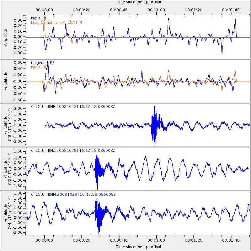
LGU LGU, Camarillo, CA, USA - Earthquake Result Viewer
*The percent match for this event was below the threshold and hence no stack was calculated.
| Earthquake location: |
Near N Coast Of New Guinea, P.N.G. |
| Earthquake latitude/longitude: |
-3.5/145.9 |
| Earthquake time(UTC): |
2008/10/28 (302) 16:00:03 GMT |
| Earthquake Depth: |
18 km |
| Earthquake Magnitude: |
5.5 MB, 5.9 MS, 6.0 MW, 6.0 MW |
| Earthquake Catalog/Contributor: |
WHDF/NEIC |
|
| Network: |
CI Caltech Regional Seismic Network |
| Station: |
LGU LGU, Camarillo, CA, USA |
| Lat/Lon: |
34.11 N/119.07 W |
| Elevation: |
416 m |
|
| Distance: |
96.1 deg |
| Az: |
56.227 deg |
| Baz: |
269.941 deg |
| Ray Param: |
$rayparam |
*The percent match for this event was below the threshold and hence was not used in the summary stack. |
|
| Radial Match: |
72.49235 % |
| Radial Bump: |
400 |
| Transverse Match: |
68.040405 % |
| Transverse Bump: |
400 |
| SOD ConfigId: |
2560 |
| Insert Time: |
2010-02-25 20:21:41.162 +0000 |
| GWidth: |
2.5 |
| Max Bumps: |
400 |
| Tol: |
0.001 |
|
Signal To Noise
| Channel | StoN | STA | LTA |
| CI:LGU: :BHZ:20081028T16:12:58.086008Z | 1.7175697 | 4.193361E-7 | 2.44145E-7 |
| CI:LGU: :BHN:20081028T16:12:58.086008Z | 2.7904103 | 8.038518E-7 | 2.8807654E-7 |
| CI:LGU: :BHE:20081028T16:12:58.086008Z | 0.895741 | 2.8550963E-7 | 3.1874126E-7 |
| Arrivals |
| Ps | |
| PpPs | |
| PsPs/PpSs | |


