You are here: Home > Network List > G - GEOSCOPE Stations List
> Station NOUC Port Laguerre, New Caledonia > Earthquake Result Viewer
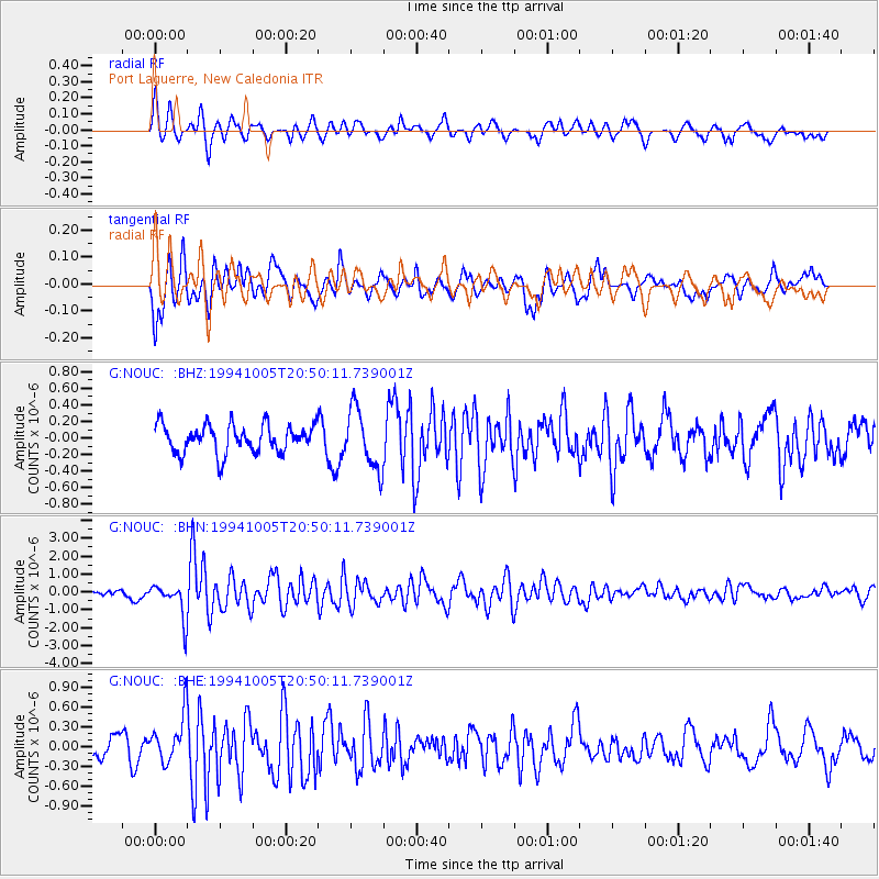
NOUC Port Laguerre, New Caledonia - Earthquake Result Viewer
*The percent match for this event was below the threshold and hence no stack was calculated.
| Earthquake location: |
Kuril Islands |
| Earthquake latitude/longitude: |
43.9/147.4 |
| Earthquake time(UTC): |
1994/10/05 (278) 20:39:47 GMT |
| Earthquake Depth: |
33 km |
| Earthquake Magnitude: |
6.2 MB, 5.6 MS, 5.9 UNKNOWN |
| Earthquake Catalog/Contributor: |
WHDF/NEIC |
|
| Network: |
G GEOSCOPE |
| Station: |
NOUC Port Laguerre, New Caledonia |
| Lat/Lon: |
22.10 S/166.30 E |
| Elevation: |
112 m |
|
| Distance: |
67.9 deg |
| Az: |
161.038 deg |
| Baz: |
345.324 deg |
| Ray Param: |
$rayparam |
*The percent match for this event was below the threshold and hence was not used in the summary stack. |
|
| Radial Match: |
75.591644 % |
| Radial Bump: |
400 |
| Transverse Match: |
76.18076 % |
| Transverse Bump: |
400 |
| SOD ConfigId: |
4480 |
| Insert Time: |
2010-02-26 23:37:18.316 +0000 |
| GWidth: |
2.5 |
| Max Bumps: |
400 |
| Tol: |
0.001 |
|
Signal To Noise
| Channel | StoN | STA | LTA |
| G:NOUC: :BHN:19941005T20:50:11.739001Z | 4.6274548 | 9.930473E-7 | 2.1459903E-7 |
| G:NOUC: :BHE:19941005T20:50:11.739001Z | 1.9417517 | 3.5857045E-7 | 1.8466338E-7 |
| G:NOUC: :BHZ:19941005T20:50:11.739001Z | 2.114049 | 3.5834697E-7 | 1.695074E-7 |
| Arrivals |
| Ps | |
| PpPs | |
| PsPs/PpSs | |


