You are here: Home > Network List > TA - USArray Transportable Network (new EarthScope stations) Stations List
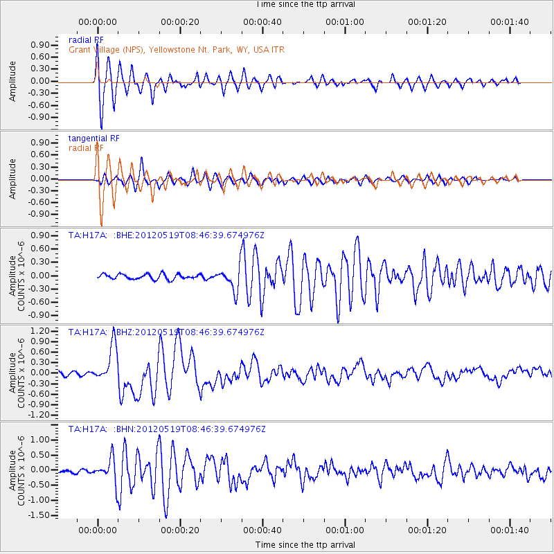
> Station H17A Grant Village (NPS), Yellowstone Nt. Park, WY, USA > Earthquake Result Viewer
H17A Grant Village (NPS), Yellowstone Nt. Park, WY, USA - Earthquake Result Viewer
| Earthquake location: |
Near Coast Of Northern Chile |
| Earthquake latitude/longitude: |
-25.7/-70.6 |
| Earthquake time(UTC): |
2012/05/19 (140) 08:35:10 GMT |
| Earthquake Depth: |
28 km |
| Earthquake Magnitude: |
5.7 MB, 5.5 MS, 5.8 MW, 5.9 MW |
| Earthquake Catalog/Contributor: |
WHDF/NEIC |
|
| Network: |
TA USArray Transportable Network (new EarthScope stations) |
| Station: |
H17A Grant Village (NPS), Yellowstone Nt. Park, WY, USA |
| Lat/Lon: |
44.40 N/110.58 W |
| Elevation: |
2400 m |
|
| Distance: |
78.8 deg |
| Az: |
331.973 deg |
| Baz: |
143.756 deg |
| Ray Param: |
0.049360458 |
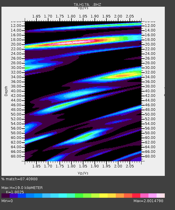
| Estimated Moho Depth: |
19.0 km |
| Estimated Crust Vp/Vs: |
1.80 |
| Assumed Crust Vp: |
6.35 km/s |
| Estimated Crust Vs: |
3.523 km/s |
| Estimated Crust Poisson's Ratio: |
0.28 |
|
| Radial Match: |
87.40988 % |
| Radial Bump: |
400 |
| Transverse Match: |
82.2662 % |
| Transverse Bump: |
400 |
| SOD ConfigId: |
446234 |
| Insert Time: |
2012-08-08 23:59:01.943 +0000 |
| GWidth: |
2.5 |
| Max Bumps: |
400 |
| Tol: |
0.001 |
|
Signal To Noise
| Channel | StoN | STA | LTA |
| TA:H17A: :BHZ:20120519T08:46:39.674976Z | 9.125941 | 5.615457E-7 | 6.153291E-8 |
| TA:H17A: :BHN:20120519T08:46:39.674976Z | 6.8721557 | 4.2017632E-7 | 6.114185E-8 |
| TA:H17A: :BHE:20120519T08:46:39.674976Z | 4.909255 | 2.8005306E-7 | 5.7045938E-8 |
| Arrivals |
| Ps | 2.5 SECOND |
| PpPs | 8.2 SECOND |
| PsPs/PpSs | 11 SECOND |


