You are here: Home > Network List > G - GEOSCOPE Stations List
> Station NOUC Port Laguerre, New Caledonia > Earthquake Result Viewer
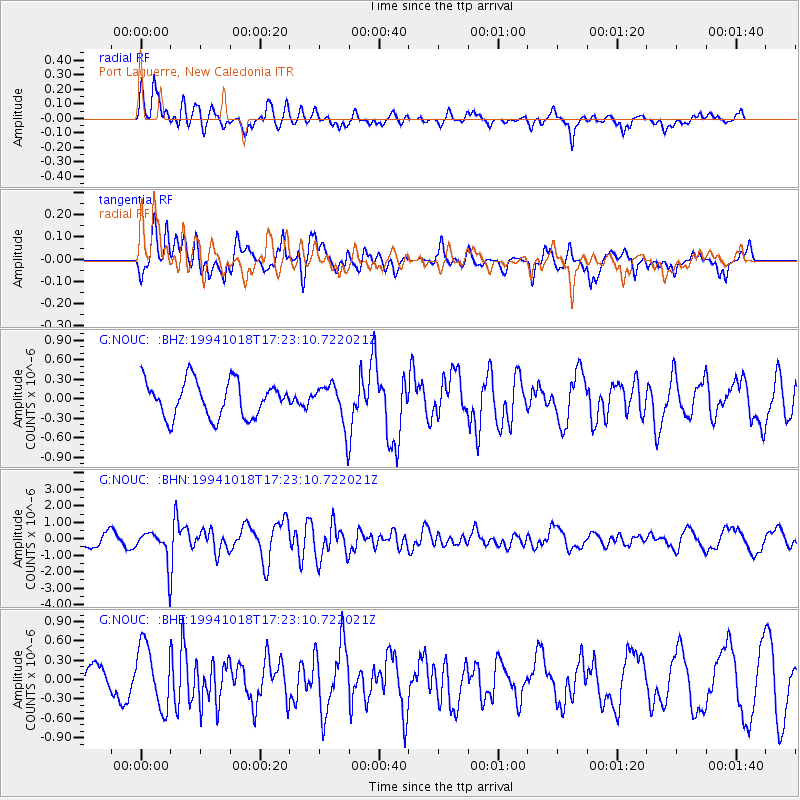
NOUC Port Laguerre, New Caledonia - Earthquake Result Viewer
*The percent match for this event was below the threshold and hence no stack was calculated.
| Earthquake location: |
Kuril Islands |
| Earthquake latitude/longitude: |
43.6/147.1 |
| Earthquake time(UTC): |
1994/10/18 (291) 17:12:51 GMT |
| Earthquake Depth: |
66 km |
| Earthquake Magnitude: |
6.1 MB, 6.1 UNKNOWN, 5.9 MW |
| Earthquake Catalog/Contributor: |
WHDF/NEIC |
|
| Network: |
G GEOSCOPE |
| Station: |
NOUC Port Laguerre, New Caledonia |
| Lat/Lon: |
22.10 S/166.30 E |
| Elevation: |
112 m |
|
| Distance: |
67.7 deg |
| Az: |
160.769 deg |
| Baz: |
345.036 deg |
| Ray Param: |
$rayparam |
*The percent match for this event was below the threshold and hence was not used in the summary stack. |
|
| Radial Match: |
74.671936 % |
| Radial Bump: |
400 |
| Transverse Match: |
66.98304 % |
| Transverse Bump: |
400 |
| SOD ConfigId: |
4480 |
| Insert Time: |
2010-02-26 23:37:26.983 +0000 |
| GWidth: |
2.5 |
| Max Bumps: |
400 |
| Tol: |
0.001 |
|
Signal To Noise
| Channel | StoN | STA | LTA |
| G:NOUC: :BHN:19941018T17:23:10.722021Z | 2.7069697 | 1.0224821E-6 | 3.7772205E-7 |
| G:NOUC: :BHE:19941018T17:23:10.722021Z | 2.1958075 | 4.868213E-7 | 2.2170491E-7 |
| G:NOUC: :BHZ:19941018T17:23:10.722021Z | 1.1788324 | 3.242607E-7 | 2.7506937E-7 |
| Arrivals |
| Ps | |
| PpPs | |
| PsPs/PpSs | |


