You are here: Home > Network List > G - GEOSCOPE Stations List
> Station NOUC Port Laguerre, New Caledonia > Earthquake Result Viewer
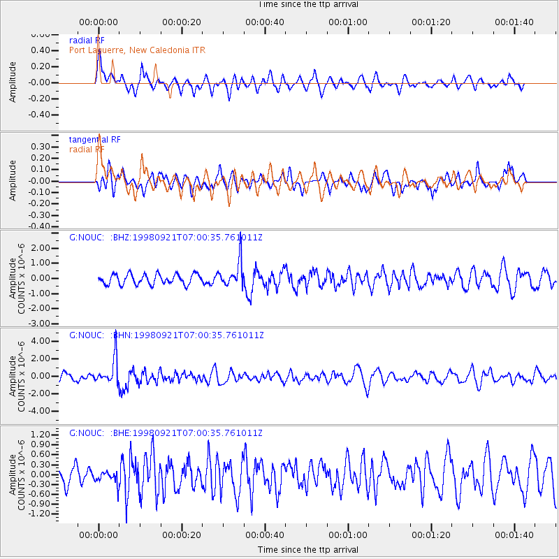
NOUC Port Laguerre, New Caledonia - Earthquake Result Viewer
*The percent match for this event was below the threshold and hence no stack was calculated.
| Earthquake location: |
Minahassa Peninsula, Sulawesi |
| Earthquake latitude/longitude: |
0.3/122.5 |
| Earthquake time(UTC): |
1998/09/21 (264) 06:52:41 GMT |
| Earthquake Depth: |
147 km |
| Earthquake Magnitude: |
6.1 MB, 6.0 UNKNOWN, 5.9 MW |
| Earthquake Catalog/Contributor: |
WHDF/NEIC |
|
| Network: |
G GEOSCOPE |
| Station: |
NOUC Port Laguerre, New Caledonia |
| Lat/Lon: |
22.10 S/166.30 E |
| Elevation: |
112 m |
|
| Distance: |
48.1 deg |
| Az: |
120.418 deg |
| Baz: |
291.587 deg |
| Ray Param: |
$rayparam |
*The percent match for this event was below the threshold and hence was not used in the summary stack. |
|
| Radial Match: |
67.75004 % |
| Radial Bump: |
400 |
| Transverse Match: |
52.83409 % |
| Transverse Bump: |
400 |
| SOD ConfigId: |
4480 |
| Insert Time: |
2010-02-26 23:37:31.152 +0000 |
| GWidth: |
2.5 |
| Max Bumps: |
400 |
| Tol: |
0.001 |
|
Signal To Noise
| Channel | StoN | STA | LTA |
| G:NOUC: :BHN:19980921T07:00:35.761011Z | 3.2764227 | 1.5054966E-6 | 4.59494E-7 |
| G:NOUC: :BHE:19980921T07:00:35.761011Z | 0.6100583 | 1.904435E-7 | 3.1217263E-7 |
| G:NOUC: :BHZ:19980921T07:00:35.761011Z | 2.6274264 | 8.8235856E-7 | 3.358262E-7 |
| Arrivals |
| Ps | |
| PpPs | |
| PsPs/PpSs | |


