You are here: Home > Network List > TA - USArray Transportable Network (new EarthScope stations) Stations List
> Station SUSD Miller, SD, USA > Earthquake Result Viewer
SUSD Miller, SD, USA - Earthquake Result Viewer
| Earthquake location: |
Near Coast Of Northern Chile |
| Earthquake latitude/longitude: |
-25.7/-70.6 |
| Earthquake time(UTC): |
2012/05/19 (140) 08:35:10 GMT |
| Earthquake Depth: |
28 km |
| Earthquake Magnitude: |
5.7 MB, 5.5 MS, 5.8 MW, 5.9 MW |
| Earthquake Catalog/Contributor: |
WHDF/NEIC |
|
| Network: |
TA USArray Transportable Network (new EarthScope stations) |
| Station: |
SUSD Miller, SD, USA |
| Lat/Lon: |
44.44 N/98.96 W |
| Elevation: |
520 m |
|
| Distance: |
74.5 deg |
| Az: |
339.301 deg |
| Baz: |
153.571 deg |
| Ray Param: |
0.052249108 |
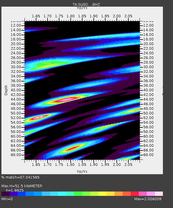
| Estimated Moho Depth: |
51.5 km |
| Estimated Crust Vp/Vs: |
1.66 |
| Assumed Crust Vp: |
6.53 km/s |
| Estimated Crust Vs: |
3.928 km/s |
| Estimated Crust Poisson's Ratio: |
0.22 |
|
| Radial Match: |
87.041565 % |
| Radial Bump: |
400 |
| Transverse Match: |
66.11988 % |
| Transverse Bump: |
400 |
| SOD ConfigId: |
446234 |
| Insert Time: |
2012-08-09 00:05:54.691 +0000 |
| GWidth: |
2.5 |
| Max Bumps: |
400 |
| Tol: |
0.001 |
|

Signal To Noise
| Channel | StoN | STA | LTA |
| TA:SUSD: :BHZ:20120519T08:46:15.499988Z | 4.9741297 | 9.881351E-7 | 1.9865487E-7 |
| TA:SUSD: :BHN:20120519T08:46:15.499988Z | 3.0547125 | 8.3973504E-7 | 2.748982E-7 |
| TA:SUSD: :BHE:20120519T08:46:15.499988Z | 1.6259954 | 3.6833174E-7 | 2.2652692E-7 |
| Arrivals |
| Ps | 5.4 SECOND |
| PpPs | 20 SECOND |
| PsPs/PpSs | 26 SECOND |


