You are here: Home > Network List > TA - USArray Transportable Network (new EarthScope stations) Stations List
> Station K37A Belmond, IA, USA > Earthquake Result Viewer
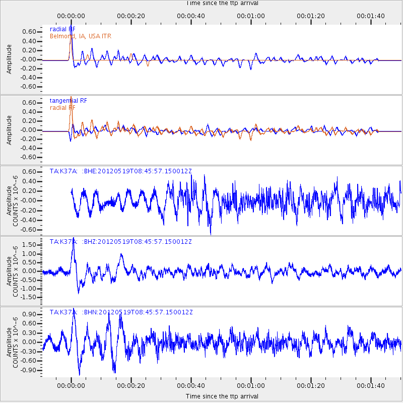
K37A Belmond, IA, USA - Earthquake Result Viewer

| Earthquake location: |
Near Coast Of Northern Chile |
| Earthquake latitude/longitude: |
-25.7/-70.6 |
| Earthquake time(UTC): |
2012/05/19 (140) 08:35:10 GMT |
| Earthquake Depth: |
28 km |
| Earthquake Magnitude: |
5.7 MB, 5.5 MS, 5.8 MW, 5.9 MW |
| Earthquake Catalog/Contributor: |
WHDF/NEIC |
|
| Network: |
TA USArray Transportable Network (new EarthScope stations) |
| Station: |
K37A Belmond, IA, USA |
| Lat/Lon: |
42.77 N/93.64 W |
| Elevation: |
365 m |
|
| Distance: |
71.4 deg |
| Az: |
342.269 deg |
| Baz: |
158.097 deg |
| Ray Param: |
0.05431554 |
| Estimated Moho Depth: |
41.5 km |
| Estimated Crust Vp/Vs: |
1.60 |
| Assumed Crust Vp: |
6.53 km/s |
| Estimated Crust Vs: |
4.075 km/s |
| Estimated Crust Poisson's Ratio: |
0.18 |
|
| Radial Match: |
86.00945 % |
| Radial Bump: |
393 |
| Transverse Match: |
56.899593 % |
| Transverse Bump: |
400 |
| SOD ConfigId: |
446234 |
| Insert Time: |
2012-08-09 00:10:19.616 +0000 |
| GWidth: |
2.5 |
| Max Bumps: |
400 |
| Tol: |
0.001 |
|
Signal To Noise
| Channel | StoN | STA | LTA |
| TA:K37A: :BHZ:20120519T08:45:57.150012Z | 4.5847893 | 8.045043E-7 | 1.7547247E-7 |
| TA:K37A: :BHN:20120519T08:45:57.150012Z | 4.1466956 | 5.339317E-7 | 1.2876077E-7 |
| TA:K37A: :BHE:20120519T08:45:57.150012Z | 1.676119 | 2.3846647E-7 | 1.4227298E-7 |
| Arrivals |
| Ps | 4.0 SECOND |
| PpPs | 16 SECOND |
| PsPs/PpSs | 20 SECOND |


