You are here: Home > Network List > TA - USArray Transportable Network (new EarthScope stations) Stations List
> Station R39A Chumby, Stover, MO, USA > Earthquake Result Viewer
R39A Chumby, Stover, MO, USA - Earthquake Result Viewer
| Earthquake location: |
Near Coast Of Northern Chile |
| Earthquake latitude/longitude: |
-25.7/-70.6 |
| Earthquake time(UTC): |
2012/05/19 (140) 08:35:10 GMT |
| Earthquake Depth: |
28 km |
| Earthquake Magnitude: |
5.7 MB, 5.5 MS, 5.8 MW, 5.9 MW |
| Earthquake Catalog/Contributor: |
WHDF/NEIC |
|
| Network: |
TA USArray Transportable Network (new EarthScope stations) |
| Station: |
R39A Chumby, Stover, MO, USA |
| Lat/Lon: |
38.31 N/93.04 W |
| Elevation: |
290 m |
|
| Distance: |
67.1 deg |
| Az: |
340.946 deg |
| Baz: |
158.017 deg |
| Ray Param: |
0.05713558 |
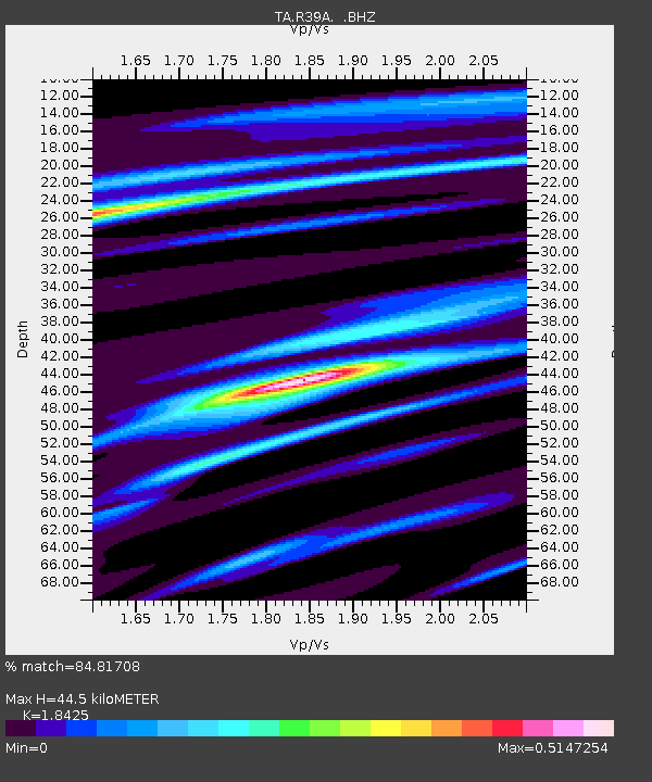
| Estimated Moho Depth: |
44.5 km |
| Estimated Crust Vp/Vs: |
1.84 |
| Assumed Crust Vp: |
6.498 km/s |
| Estimated Crust Vs: |
3.526 km/s |
| Estimated Crust Poisson's Ratio: |
0.29 |
|
| Radial Match: |
84.81708 % |
| Radial Bump: |
260 |
| Transverse Match: |
65.52259 % |
| Transverse Bump: |
400 |
| SOD ConfigId: |
446234 |
| Insert Time: |
2012-08-09 00:13:51.463 +0000 |
| GWidth: |
2.5 |
| Max Bumps: |
400 |
| Tol: |
0.001 |
|
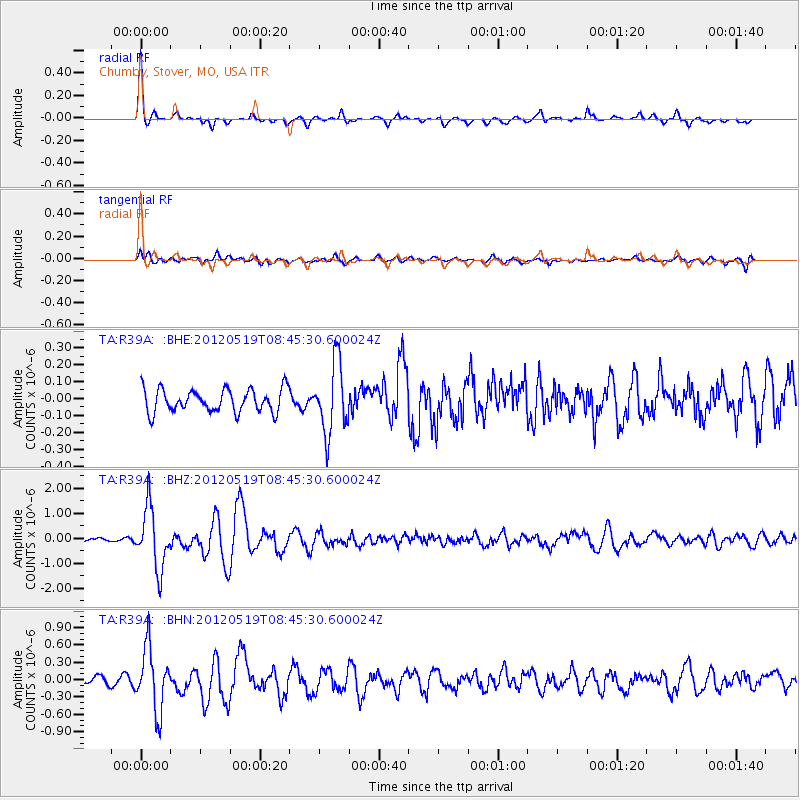
Signal To Noise
| Channel | StoN | STA | LTA |
| TA:R39A: :BHZ:20120519T08:45:30.600024Z | 10.278285 | 1.2048567E-6 | 1.17223514E-7 |
| TA:R39A: :BHN:20120519T08:45:30.600024Z | 5.7865605 | 5.3625945E-7 | 9.267327E-8 |
| TA:R39A: :BHE:20120519T08:45:30.600024Z | 3.0462728 | 2.0619068E-7 | 6.7686216E-8 |
| Arrivals |
| Ps | 6.0 SECOND |
| PpPs | 19 SECOND |
| PsPs/PpSs | 25 SECOND |


