You are here: Home > Network List > TA - USArray Transportable Network (new EarthScope stations) Stations List
> Station Y46A Houston, MS, USA > Earthquake Result Viewer
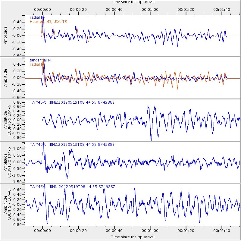
Y46A Houston, MS, USA - Earthquake Result Viewer
*The percent match for this event was below the threshold and hence no stack was calculated.
| Earthquake location: |
Near Coast Of Northern Chile |
| Earthquake latitude/longitude: |
-25.7/-70.6 |
| Earthquake time(UTC): |
2012/05/19 (140) 08:35:10 GMT |
| Earthquake Depth: |
28 km |
| Earthquake Magnitude: |
5.7 MB, 5.5 MS, 5.8 MW, 5.9 MW |
| Earthquake Catalog/Contributor: |
WHDF/NEIC |
|
| Network: |
TA USArray Transportable Network (new EarthScope stations) |
| Station: |
Y46A Houston, MS, USA |
| Lat/Lon: |
33.88 N/88.86 W |
| Elevation: |
109 m |
|
| Distance: |
61.8 deg |
| Az: |
342.76 deg |
| Baz: |
161.255 deg |
| Ray Param: |
$rayparam |
*The percent match for this event was below the threshold and hence was not used in the summary stack. |
|
| Radial Match: |
57.573112 % |
| Radial Bump: |
400 |
| Transverse Match: |
64.406364 % |
| Transverse Bump: |
400 |
| SOD ConfigId: |
446234 |
| Insert Time: |
2012-08-09 00:20:33.801 +0000 |
| GWidth: |
2.5 |
| Max Bumps: |
400 |
| Tol: |
0.001 |
|
Signal To Noise
| Channel | StoN | STA | LTA |
| TA:Y46A: :BHZ:20120519T08:44:55.874988Z | 4.939564 | 5.922047E-7 | 1.1989007E-7 |
| TA:Y46A: :BHN:20120519T08:44:55.874988Z | 1.605959 | 3.9679313E-7 | 2.470755E-7 |
| TA:Y46A: :BHE:20120519T08:44:55.874988Z | 1.487032 | 2.1578079E-7 | 1.4510837E-7 |
| Arrivals |
| Ps | |
| PpPs | |
| PsPs/PpSs | |


