You are here: Home > Network List > TA - USArray Transportable Network (new EarthScope stations) Stations List
> Station X44A Crenshaw, MS, USA > Earthquake Result Viewer
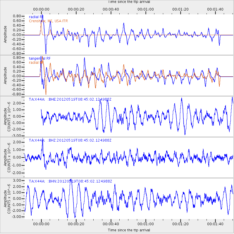
X44A Crenshaw, MS, USA - Earthquake Result Viewer
*The percent match for this event was below the threshold and hence no stack was calculated.
| Earthquake location: |
Near Coast Of Northern Chile |
| Earthquake latitude/longitude: |
-25.7/-70.6 |
| Earthquake time(UTC): |
2012/05/19 (140) 08:35:10 GMT |
| Earthquake Depth: |
28 km |
| Earthquake Magnitude: |
5.7 MB, 5.5 MS, 5.8 MW, 5.9 MW |
| Earthquake Catalog/Contributor: |
WHDF/NEIC |
|
| Network: |
TA USArray Transportable Network (new EarthScope stations) |
| Station: |
X44A Crenshaw, MS, USA |
| Lat/Lon: |
34.50 N/90.15 W |
| Elevation: |
109 m |
|
| Distance: |
62.7 deg |
| Az: |
341.851 deg |
| Baz: |
160.111 deg |
| Ray Param: |
$rayparam |
*The percent match for this event was below the threshold and hence was not used in the summary stack. |
|
| Radial Match: |
63.492607 % |
| Radial Bump: |
311 |
| Transverse Match: |
59.823547 % |
| Transverse Bump: |
369 |
| SOD ConfigId: |
446234 |
| Insert Time: |
2012-08-09 00:21:47.836 +0000 |
| GWidth: |
2.5 |
| Max Bumps: |
400 |
| Tol: |
0.001 |
|
Signal To Noise
| Channel | StoN | STA | LTA |
| TA:X44A: :BHZ:20120519T08:45:02.124988Z | 2.9424336 | 8.8946126E-7 | 3.0228765E-7 |
| TA:X44A: :BHN:20120519T08:45:02.124988Z | 0.85612917 | 8.876538E-7 | 1.0368223E-6 |
| TA:X44A: :BHE:20120519T08:45:02.124988Z | 3.4424202 | 1.4537432E-6 | 4.2230263E-7 |
| Arrivals |
| Ps | |
| PpPs | |
| PsPs/PpSs | |


