You are here: Home > Network List > TA - USArray Transportable Network (new EarthScope stations) Stations List
> Station T42A Van Buren, MO, USA > Earthquake Result Viewer
T42A Van Buren, MO, USA - Earthquake Result Viewer
| Earthquake location: |
Near Coast Of Northern Chile |
| Earthquake latitude/longitude: |
-25.7/-70.6 |
| Earthquake time(UTC): |
2012/05/19 (140) 08:35:10 GMT |
| Earthquake Depth: |
28 km |
| Earthquake Magnitude: |
5.7 MB, 5.5 MS, 5.8 MW, 5.9 MW |
| Earthquake Catalog/Contributor: |
WHDF/NEIC |
|
| Network: |
TA USArray Transportable Network (new EarthScope stations) |
| Station: |
T42A Van Buren, MO, USA |
| Lat/Lon: |
37.03 N/91.09 W |
| Elevation: |
162 m |
|
| Distance: |
65.3 deg |
| Az: |
342.013 deg |
| Baz: |
159.632 deg |
| Ray Param: |
0.058288947 |
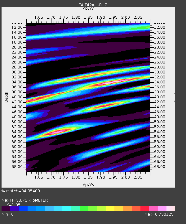
| Estimated Moho Depth: |
33.75 km |
| Estimated Crust Vp/Vs: |
1.95 |
| Assumed Crust Vp: |
6.53 km/s |
| Estimated Crust Vs: |
3.349 km/s |
| Estimated Crust Poisson's Ratio: |
0.32 |
|
| Radial Match: |
84.05489 % |
| Radial Bump: |
400 |
| Transverse Match: |
69.9281 % |
| Transverse Bump: |
400 |
| SOD ConfigId: |
446234 |
| Insert Time: |
2012-08-09 00:28:20.738 +0000 |
| GWidth: |
2.5 |
| Max Bumps: |
400 |
| Tol: |
0.001 |
|
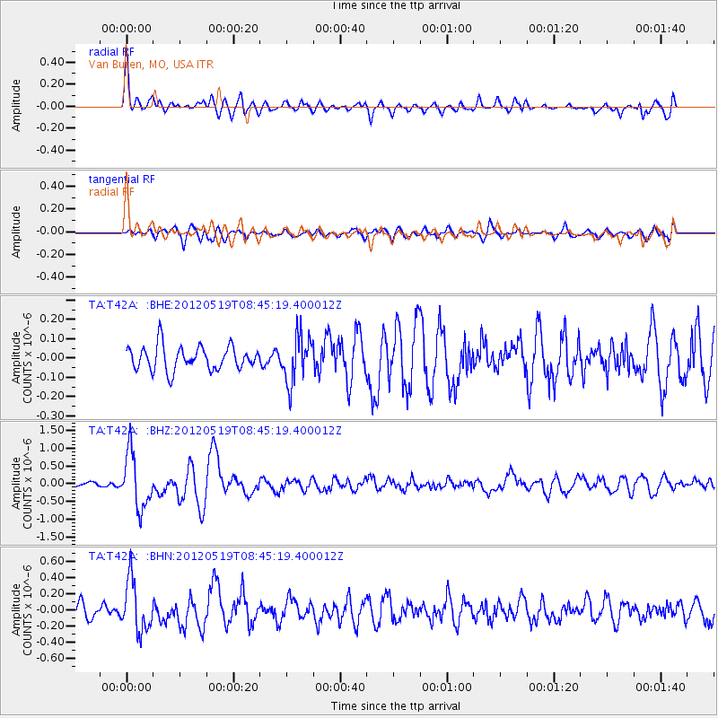
Signal To Noise
| Channel | StoN | STA | LTA |
| TA:T42A: :BHZ:20120519T08:45:19.400012Z | 8.277881 | 7.8278157E-7 | 9.456304E-8 |
| TA:T42A: :BHN:20120519T08:45:19.400012Z | 2.993194 | 3.1796972E-7 | 1.0623091E-7 |
| TA:T42A: :BHE:20120519T08:45:19.400012Z | 1.9730533 | 1.2215163E-7 | 6.190995E-8 |
| Arrivals |
| Ps | 5.1 SECOND |
| PpPs | 15 SECOND |
| PsPs/PpSs | 20 SECOND |


