You are here: Home > Network List > TA - USArray Transportable Network (new EarthScope stations) Stations List
> Station E41A Kenton, MI, USA > Earthquake Result Viewer
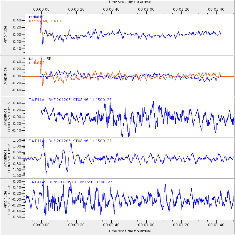
E41A Kenton, MI, USA - Earthquake Result Viewer
*The percent match for this event was below the threshold and hence no stack was calculated.
| Earthquake location: |
Near Coast Of Northern Chile |
| Earthquake latitude/longitude: |
-25.7/-70.6 |
| Earthquake time(UTC): |
2012/05/19 (140) 08:35:10 GMT |
| Earthquake Depth: |
28 km |
| Earthquake Magnitude: |
5.7 MB, 5.5 MS, 5.8 MW, 5.9 MW |
| Earthquake Catalog/Contributor: |
WHDF/NEIC |
|
| Network: |
TA USArray Transportable Network (new EarthScope stations) |
| Station: |
E41A Kenton, MI, USA |
| Lat/Lon: |
46.46 N/88.96 W |
| Elevation: |
377 m |
|
| Distance: |
73.8 deg |
| Az: |
346.864 deg |
| Baz: |
162.749 deg |
| Ray Param: |
$rayparam |
*The percent match for this event was below the threshold and hence was not used in the summary stack. |
|
| Radial Match: |
72.330696 % |
| Radial Bump: |
400 |
| Transverse Match: |
63.173874 % |
| Transverse Bump: |
400 |
| SOD ConfigId: |
446234 |
| Insert Time: |
2012-08-09 00:29:35.809 +0000 |
| GWidth: |
2.5 |
| Max Bumps: |
400 |
| Tol: |
0.001 |
|
Signal To Noise
| Channel | StoN | STA | LTA |
| TA:E41A: :BHZ:20120519T08:46:11.150012Z | 5.70033 | 7.7271255E-7 | 1.3555577E-7 |
| TA:E41A: :BHN:20120519T08:46:11.150012Z | 2.9524205 | 3.3098843E-7 | 1.12107486E-7 |
| TA:E41A: :BHE:20120519T08:46:11.150012Z | 0.9285348 | 1.0430727E-7 | 1.1233533E-7 |
| Arrivals |
| Ps | |
| PpPs | |
| PsPs/PpSs | |


