You are here: Home > Network List > TA - USArray Transportable Network (new EarthScope stations) Stations List
> Station U48A Cassie Pea, Portland, TN, USA > Earthquake Result Viewer
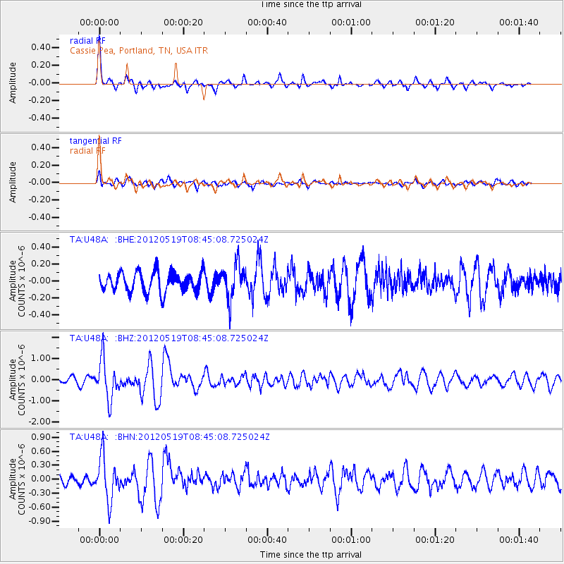
U48A Cassie Pea, Portland, TN, USA - Earthquake Result Viewer
| Earthquake location: |
Near Coast Of Northern Chile |
| Earthquake latitude/longitude: |
-25.7/-70.6 |
| Earthquake time(UTC): |
2012/05/19 (140) 08:35:10 GMT |
| Earthquake Depth: |
28 km |
| Earthquake Magnitude: |
5.7 MB, 5.5 MS, 5.8 MW, 5.9 MW |
| Earthquake Catalog/Contributor: |
WHDF/NEIC |
|
| Network: |
TA USArray Transportable Network (new EarthScope stations) |
| Station: |
U48A Cassie Pea, Portland, TN, USA |
| Lat/Lon: |
36.51 N/86.54 W |
| Elevation: |
268 m |
|
| Distance: |
63.7 deg |
| Az: |
345.679 deg |
| Baz: |
163.923 deg |
| Ray Param: |
0.05935585 |
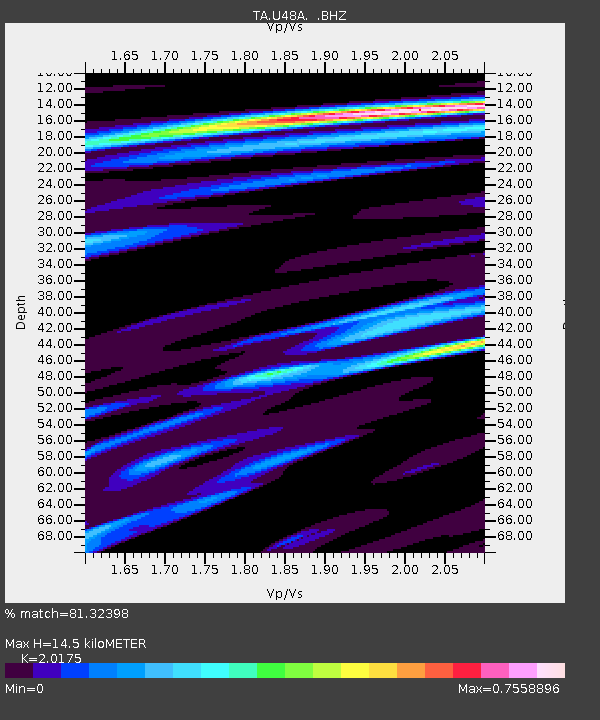
| Estimated Moho Depth: |
14.5 km |
| Estimated Crust Vp/Vs: |
2.02 |
| Assumed Crust Vp: |
6.444 km/s |
| Estimated Crust Vs: |
3.194 km/s |
| Estimated Crust Poisson's Ratio: |
0.34 |
|
| Radial Match: |
81.32398 % |
| Radial Bump: |
345 |
| Transverse Match: |
47.5297 % |
| Transverse Bump: |
400 |
| SOD ConfigId: |
446234 |
| Insert Time: |
2012-08-09 00:34:40.125 +0000 |
| GWidth: |
2.5 |
| Max Bumps: |
400 |
| Tol: |
0.001 |
|
Signal To Noise
| Channel | StoN | STA | LTA |
| TA:U48A: :BHZ:20120519T08:45:08.725024Z | 7.054813 | 9.521252E-7 | 1.349611E-7 |
| TA:U48A: :BHN:20120519T08:45:08.725024Z | 5.1368155 | 4.6953636E-7 | 9.140612E-8 |
| TA:U48A: :BHE:20120519T08:45:08.725024Z | 1.7599853 | 2.0555375E-7 | 1.1679287E-7 |
| Arrivals |
| Ps | 2.4 SECOND |
| PpPs | 6.5 SECOND |
| PsPs/PpSs | 8.9 SECOND |


