You are here: Home > Network List > TA - USArray Transportable Network (new EarthScope stations) Stations List
> Station G59A Clarenceville, QC, USA > Earthquake Result Viewer
G59A Clarenceville, QC, USA - Earthquake Result Viewer
*The percent match for this event was below the threshold and hence no stack was calculated.
| Earthquake location: |
Off Coast Of Oregon |
| Earthquake latitude/longitude: |
43.7/-128.1 |
| Earthquake time(UTC): |
2014/05/12 (132) 18:51:00 GMT |
| Earthquake Depth: |
14 km |
| Earthquake Magnitude: |
5.5 MW |
| Earthquake Catalog/Contributor: |
ISC/ISC |
|
| Network: |
TA USArray Transportable Network (new EarthScope stations) |
| Station: |
G59A Clarenceville, QC, USA |
| Lat/Lon: |
45.08 N/73.18 W |
| Elevation: |
36 m |
|
| Distance: |
38.7 deg |
| Az: |
68.221 deg |
| Baz: |
288.088 deg |
| Ray Param: |
$rayparam |
*The percent match for this event was below the threshold and hence was not used in the summary stack. |
|
| Radial Match: |
75.4433 % |
| Radial Bump: |
400 |
| Transverse Match: |
71.3746 % |
| Transverse Bump: |
400 |
| SOD ConfigId: |
3390531 |
| Insert Time: |
2019-04-11 20:18:33.754 +0000 |
| GWidth: |
2.5 |
| Max Bumps: |
400 |
| Tol: |
0.001 |
|
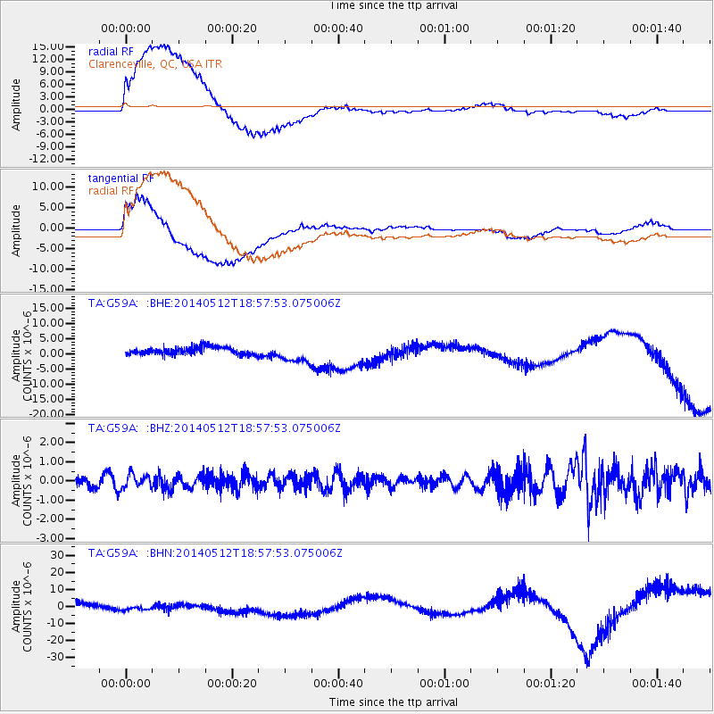
Signal To Noise
| Channel | StoN | STA | LTA |
| TA:G59A: :BHZ:20140512T18:57:53.075006Z | 1.0956849 | 3.418862E-7 | 3.1202967E-7 |
| TA:G59A: :BHN:20140512T18:57:53.075006Z | 0.8383835 | 2.0349073E-6 | 2.4271794E-6 |
| TA:G59A: :BHE:20140512T18:57:53.075006Z | 2.5919044 | 3.219321E-6 | 1.2420677E-6 |
| Arrivals |
| Ps | |
| PpPs | |
| PsPs/PpSs | |


