You are here: Home > Network List > TA - USArray Transportable Network (new EarthScope stations) Stations List
> Station 356A Blackshear, GA, USA > Earthquake Result Viewer
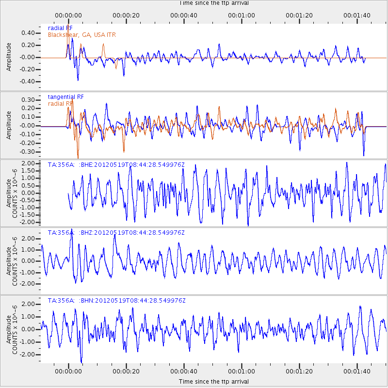
356A Blackshear, GA, USA - Earthquake Result Viewer
*The percent match for this event was below the threshold and hence no stack was calculated.
| Earthquake location: |
Near Coast Of Northern Chile |
| Earthquake latitude/longitude: |
-25.7/-70.6 |
| Earthquake time(UTC): |
2012/05/19 (140) 08:35:10 GMT |
| Earthquake Depth: |
28 km |
| Earthquake Magnitude: |
5.7 MB, 5.5 MS, 5.8 MW, 5.9 MW |
| Earthquake Catalog/Contributor: |
WHDF/NEIC |
|
| Network: |
TA USArray Transportable Network (new EarthScope stations) |
| Station: |
356A Blackshear, GA, USA |
| Lat/Lon: |
31.32 N/82.13 W |
| Elevation: |
36 m |
|
| Distance: |
57.8 deg |
| Az: |
348.302 deg |
| Baz: |
167.66 deg |
| Ray Param: |
$rayparam |
*The percent match for this event was below the threshold and hence was not used in the summary stack. |
|
| Radial Match: |
61.40867 % |
| Radial Bump: |
400 |
| Transverse Match: |
45.255722 % |
| Transverse Bump: |
400 |
| SOD ConfigId: |
446234 |
| Insert Time: |
2012-08-09 00:39:16.882 +0000 |
| GWidth: |
2.5 |
| Max Bumps: |
400 |
| Tol: |
0.001 |
|
Signal To Noise
| Channel | StoN | STA | LTA |
| TA:356A: :BHZ:20120519T08:44:28.549976Z | 2.1084502 | 1.3473986E-6 | 6.3904696E-7 |
| TA:356A: :BHN:20120519T08:44:28.549976Z | 1.6556847 | 1.0827744E-6 | 6.5397376E-7 |
| TA:356A: :BHE:20120519T08:44:28.549976Z | 0.81112957 | 6.384083E-7 | 7.870608E-7 |
| Arrivals |
| Ps | |
| PpPs | |
| PsPs/PpSs | |


