You are here: Home > Network List > G - GEOSCOPE Stations List
> Station NOUC Port Laguerre, New Caledonia > Earthquake Result Viewer
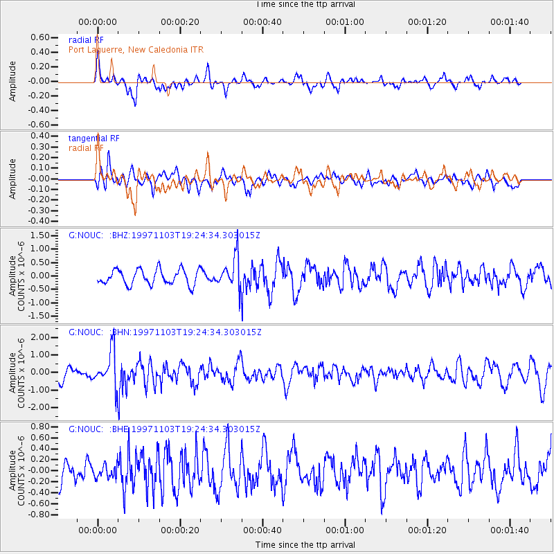
NOUC Port Laguerre, New Caledonia - Earthquake Result Viewer
*The percent match for this event was below the threshold and hence no stack was calculated.
| Earthquake location: |
Banda Sea |
| Earthquake latitude/longitude: |
-6.7/129.0 |
| Earthquake time(UTC): |
1997/11/03 (307) 19:17:58 GMT |
| Earthquake Depth: |
216 km |
| Earthquake Magnitude: |
5.7 MB, 6.1 UNKNOWN |
| Earthquake Catalog/Contributor: |
WHDF/NEIC |
|
| Network: |
G GEOSCOPE |
| Station: |
NOUC Port Laguerre, New Caledonia |
| Lat/Lon: |
22.10 S/166.30 E |
| Elevation: |
112 m |
|
| Distance: |
39.1 deg |
| Az: |
116.945 deg |
| Baz: |
287.315 deg |
| Ray Param: |
$rayparam |
*The percent match for this event was below the threshold and hence was not used in the summary stack. |
|
| Radial Match: |
65.230064 % |
| Radial Bump: |
400 |
| Transverse Match: |
58.30263 % |
| Transverse Bump: |
400 |
| SOD ConfigId: |
4480 |
| Insert Time: |
2010-02-26 23:38:08.504 +0000 |
| GWidth: |
2.5 |
| Max Bumps: |
400 |
| Tol: |
0.001 |
|
Signal To Noise
| Channel | StoN | STA | LTA |
| G:NOUC: :BHN:19971103T19:24:34.303015Z | 3.5529902 | 1.0850683E-6 | 3.0539582E-7 |
| G:NOUC: :BHE:19971103T19:24:34.303015Z | 0.6773356 | 1.17517345E-7 | 1.7349943E-7 |
| G:NOUC: :BHZ:19971103T19:24:34.303015Z | 2.1419408 | 6.041184E-7 | 2.8204252E-7 |
| Arrivals |
| Ps | |
| PpPs | |
| PsPs/PpSs | |


