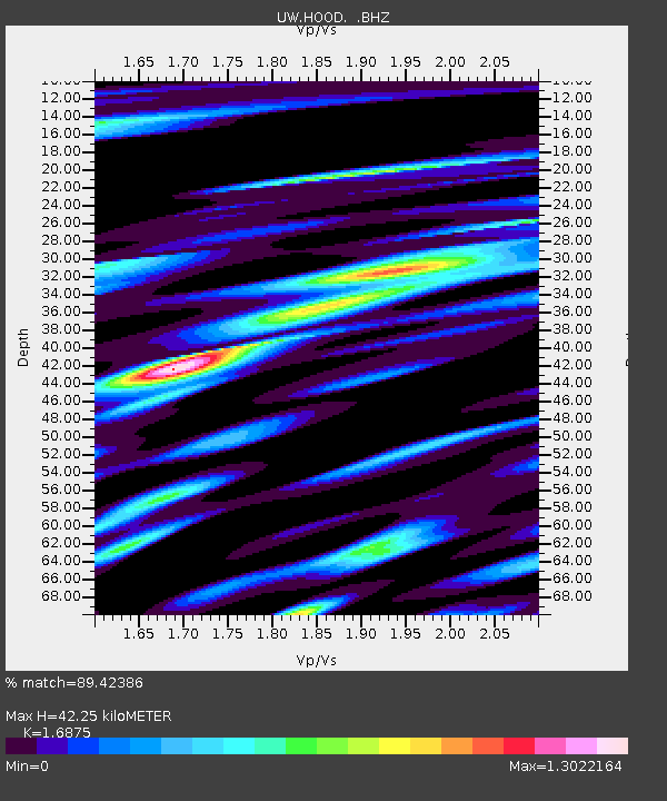
HOOD Mt Hood Meadows, OR CREST BB SMO - Earthquake Result Viewer

Earthquake location: Near Coast Of Northern Chile
Earthquake latitude/longitude: -25.7/-70.6
Earthquake time(UTC): 2012/05/19 (140) 08:35:10 GMT
Earthquake Depth: 28 km
Earthquake Magnitude: 5.7 MB, 5.5 MS, 5.8 MW, 5.9 MW
Earthquake Catalog/Contributor: WHDF/NEIC
Network: UW Pacific Northwest Regional Seismic Network
Station: HOOD Mt Hood Meadows, OR CREST BB SMO
Lat/Lon: 45.32 N/121.65 W
Elevation: 1520 m
Distance: 84.6 deg
Az: 326.536 deg
Baz: 135.172 deg
Ray Param: 0.045316372
Estimated Moho Depth: 42.25 km
Estimated Crust Vp/Vs: 1.69
Assumed Crust Vp: 6.597 km/s
Estimated Crust Vs: 3.91 km/s
Estimated Crust Poisson's Ratio: 0.23
Radial Match: 89.42386 %
Radial Bump: 379
Transverse Match: 74.66613 %
Transverse Bump: 400
SOD ConfigId: 446234
Insert Time: 2012-08-09 00:43:52.914 +0000
GWidth: 2.5
Max Bumps: 400
Tol: 0.001

Signal To Noise

ChannelStoNSTALTA
UW:HOOD: :BHZ:20120519T08:47:10.234973Z9.8858687.8245836E-77.9149174E-8
UW:HOOD: :BHN:20120519T08:47:10.234973Z4.06943373.8287854E-79.4086445E-8
UW:HOOD: :BHE:20120519T08:47:10.234973Z2.6777823.5244557E-71.3161846E-7
Arrivals
Ps4.5 SECOND
PpPs17 SECOND
PsPs/PpSs21 SECOND