You are here: Home > Network List > CI - Caltech Regional Seismic Network Stations List
> Station MPM Manuel Prospect Mine, California, USA > Earthquake Result Viewer
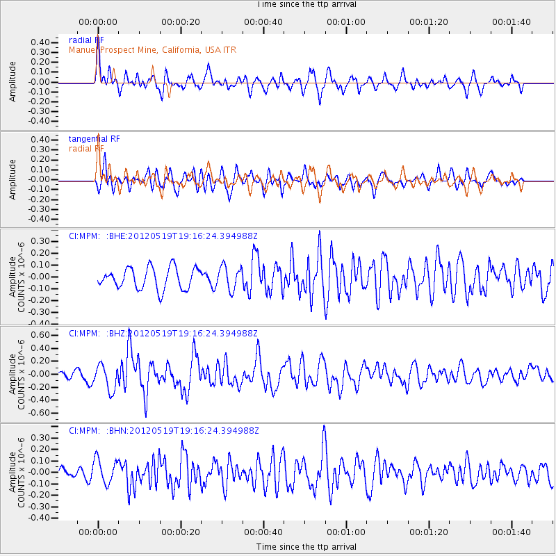
MPM Manuel Prospect Mine, California, USA - Earthquake Result Viewer
*The percent match for this event was below the threshold and hence no stack was calculated.
| Earthquake location: |
Off East Coast Of Honshu, Japan |
| Earthquake latitude/longitude: |
39.7/143.3 |
| Earthquake time(UTC): |
2012/05/19 (140) 19:05:18 GMT |
| Earthquake Depth: |
10 km |
| Earthquake Magnitude: |
5.6 MB, 5.5 MS, 5.9 MW, 5.8 MW |
| Earthquake Catalog/Contributor: |
WHDF/NEIC |
|
| Network: |
CI Caltech Regional Seismic Network |
| Station: |
MPM Manuel Prospect Mine, California, USA |
| Lat/Lon: |
36.06 N/117.49 W |
| Elevation: |
185 m |
|
| Distance: |
74.2 deg |
| Az: |
56.238 deg |
| Baz: |
307.632 deg |
| Ray Param: |
$rayparam |
*The percent match for this event was below the threshold and hence was not used in the summary stack. |
|
| Radial Match: |
63.55123 % |
| Radial Bump: |
400 |
| Transverse Match: |
64.43326 % |
| Transverse Bump: |
400 |
| SOD ConfigId: |
446234 |
| Insert Time: |
2012-08-09 00:54:47.813 +0000 |
| GWidth: |
2.5 |
| Max Bumps: |
400 |
| Tol: |
0.001 |
|
Signal To Noise
| Channel | StoN | STA | LTA |
| CI:MPM: :BHZ:20120519T19:16:24.394988Z | 3.4001884 | 1.9660838E-7 | 5.7822792E-8 |
| CI:MPM: :BHN:20120519T19:16:24.394988Z | 1.7232269 | 1.076967E-7 | 6.249711E-8 |
| CI:MPM: :BHE:20120519T19:16:24.394988Z | 1.1213403 | 1.0037817E-7 | 8.951625E-8 |
| Arrivals |
| Ps | |
| PpPs | |
| PsPs/PpSs | |


