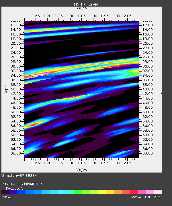
TIP Timpagrande, Italy - Earthquake Result Viewer
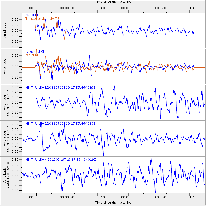
Earthquake location: Off East Coast Of Honshu, Japan
Earthquake latitude/longitude: 39.7/143.3
Earthquake time(UTC): 2012/05/19 (140) 19:05:18 GMT
Earthquake Depth: 10 km
Earthquake Magnitude: 5.6 MB, 5.5 MS, 5.9 MW, 5.8 MW
Earthquake Catalog/Contributor: WHDF/NEIC
Network: MN MEDNET Project
Station: TIP Timpagrande, Italy
Lat/Lon: 39.18 N/16.76 E
Elevation: 789 m
Distance: 87.6 deg
Az: 321.322 deg
Baz: 38.362 deg
Ray Param: 0.04324514
Estimated Moho Depth: 33.5 km
Estimated Crust Vp/Vs: 1.66
Assumed Crust Vp: 6.1 km/s
Estimated Crust Vs: 3.68 km/s
Estimated Crust Poisson's Ratio: 0.21
Radial Match: 87.89334 %
Radial Bump: 400
Transverse Match: 77.852234 %
Transverse Bump: 400
SOD ConfigId: 446234
Insert Time: 2012-08-09 01:03:16.429 +0000
GWidth: 2.5
Max Bumps: 400
Tol: 0.001

Signal To Noise

ChannelStoNSTALTA
MN:TIP: :BHZ:20120519T19:17:35.464019Z6.3213443.8197362E-76.042602E-8
MN:TIP: :BHN:20120519T19:17:35.464019Z1.81822757.166992E-83.941747E-8
MN:TIP: :BHE:20120519T19:17:35.464019Z1.96399021.1538575E-75.8750675E-8
Arrivals
Ps3.7 SECOND
PpPs14 SECOND
PsPs/PpSs18 SECOND