You are here: Home > Network List > G - GEOSCOPE Stations List
> Station NOUC Port Laguerre, New Caledonia > Earthquake Result Viewer
NOUC Port Laguerre, New Caledonia - Earthquake Result Viewer
*The percent match for this event was below the threshold and hence no stack was calculated.
| Earthquake location: |
West Of Macquarie Island |
| Earthquake latitude/longitude: |
-60.4/152.7 |
| Earthquake time(UTC): |
1993/06/29 (180) 07:07:11 GMT |
| Earthquake Depth: |
10 km |
| Earthquake Magnitude: |
5.8 MS, 4.9 MB |
| Earthquake Catalog/Contributor: |
WHDF/NEIC |
|
| Network: |
G GEOSCOPE |
| Station: |
NOUC Port Laguerre, New Caledonia |
| Lat/Lon: |
22.10 S/166.30 E |
| Elevation: |
112 m |
|
| Distance: |
39.5 deg |
| Az: |
20.094 deg |
| Baz: |
190.594 deg |
| Ray Param: |
$rayparam |
*The percent match for this event was below the threshold and hence was not used in the summary stack. |
|
| Radial Match: |
55.747746 % |
| Radial Bump: |
349 |
| Transverse Match: |
41.846962 % |
| Transverse Bump: |
400 |
| SOD ConfigId: |
4480 |
| Insert Time: |
2010-02-26 23:38:25.446 +0000 |
| GWidth: |
2.5 |
| Max Bumps: |
400 |
| Tol: |
0.001 |
|
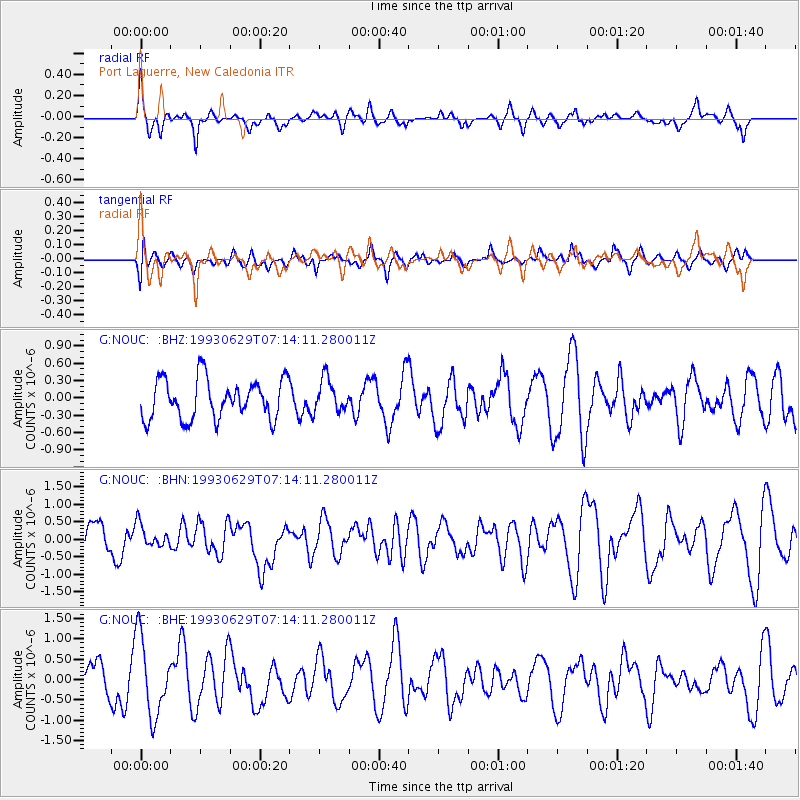
Signal To Noise
| Channel | StoN | STA | LTA |
| G:NOUC: :BHN:19930629T07:14:11.280011Z | 0.9473257 | 3.2815905E-7 | 3.4640573E-7 |
| G:NOUC: :BHE:19930629T07:14:11.280011Z | 2.7016244 | 9.553271E-7 | 3.5361214E-7 |
| G:NOUC: :BHZ:19930629T07:14:11.280011Z | 0.8322929 | 2.8513963E-7 | 3.4259529E-7 |
| Arrivals |
| Ps | |
| PpPs | |
| PsPs/PpSs | |


