You are here: Home > Network List > G - GEOSCOPE Stations List
> Station NOUC Port Laguerre, New Caledonia > Earthquake Result Viewer
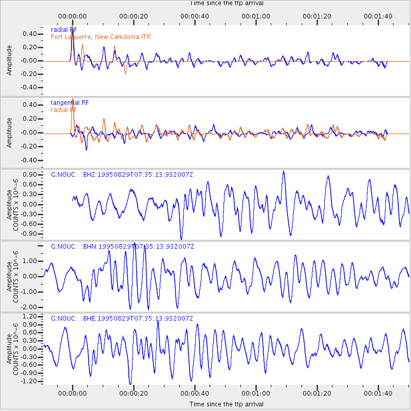
NOUC Port Laguerre, New Caledonia - Earthquake Result Viewer
*The percent match for this event was below the threshold and hence no stack was calculated.
| Earthquake location: |
Southeast Indian Ridge |
| Earthquake latitude/longitude: |
-48.0/99.5 |
| Earthquake time(UTC): |
1995/08/29 (241) 07:25:48 GMT |
| Earthquake Depth: |
10 km |
| Earthquake Magnitude: |
5.3 MB, 6.2 MS, 5.7 UNKNOWN, 6.4 MW |
| Earthquake Catalog/Contributor: |
WHDF/NEIC |
|
| Network: |
G GEOSCOPE |
| Station: |
NOUC Port Laguerre, New Caledonia |
| Lat/Lon: |
22.10 S/166.30 E |
| Elevation: |
112 m |
|
| Distance: |
58.5 deg |
| Az: |
88.737 deg |
| Baz: |
226.399 deg |
| Ray Param: |
$rayparam |
*The percent match for this event was below the threshold and hence was not used in the summary stack. |
|
| Radial Match: |
56.56183 % |
| Radial Bump: |
400 |
| Transverse Match: |
58.420967 % |
| Transverse Bump: |
400 |
| SOD ConfigId: |
4480 |
| Insert Time: |
2010-02-26 23:38:27.007 +0000 |
| GWidth: |
2.5 |
| Max Bumps: |
400 |
| Tol: |
0.001 |
|
Signal To Noise
| Channel | StoN | STA | LTA |
| G:NOUC: :BHN:19950829T07:35:13.932007Z | 1.651745 | 6.912517E-7 | 4.1849788E-7 |
| G:NOUC: :BHE:19950829T07:35:13.932007Z | 1.5634047 | 3.711263E-7 | 2.373834E-7 |
| G:NOUC: :BHZ:19950829T07:35:13.932007Z | 0.8461896 | 2.1252153E-7 | 2.511512E-7 |
| Arrivals |
| Ps | |
| PpPs | |
| PsPs/PpSs | |


