You are here: Home > Network List > TA - USArray Transportable Network (new EarthScope stations) Stations List
> Station A33A Warroad, MN, USA > Earthquake Result Viewer
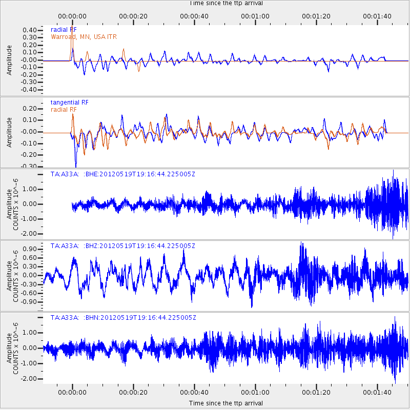
A33A Warroad, MN, USA - Earthquake Result Viewer
*The percent match for this event was below the threshold and hence no stack was calculated.
| Earthquake location: |
Off East Coast Of Honshu, Japan |
| Earthquake latitude/longitude: |
39.7/143.3 |
| Earthquake time(UTC): |
2012/05/19 (140) 19:05:18 GMT |
| Earthquake Depth: |
10 km |
| Earthquake Magnitude: |
5.6 MB, 5.5 MS, 5.9 MW, 5.8 MW |
| Earthquake Catalog/Contributor: |
WHDF/NEIC |
|
| Network: |
TA USArray Transportable Network (new EarthScope stations) |
| Station: |
A33A Warroad, MN, USA |
| Lat/Lon: |
48.94 N/95.39 W |
| Elevation: |
329 m |
|
| Distance: |
77.7 deg |
| Az: |
35.221 deg |
| Baz: |
317.536 deg |
| Ray Param: |
$rayparam |
*The percent match for this event was below the threshold and hence was not used in the summary stack. |
|
| Radial Match: |
46.703022 % |
| Radial Bump: |
397 |
| Transverse Match: |
65.43016 % |
| Transverse Bump: |
400 |
| SOD ConfigId: |
446234 |
| Insert Time: |
2012-08-09 01:10:04.983 +0000 |
| GWidth: |
2.5 |
| Max Bumps: |
400 |
| Tol: |
0.001 |
|
Signal To Noise
| Channel | StoN | STA | LTA |
| TA:A33A: :BHZ:20120519T19:16:44.225005Z | 2.4225948 | 3.768306E-7 | 1.5554834E-7 |
| TA:A33A: :BHN:20120519T19:16:44.225005Z | 1.4761823 | 2.900544E-7 | 1.9648955E-7 |
| TA:A33A: :BHE:20120519T19:16:44.225005Z | 1.4690961 | 3.0350543E-7 | 2.0659331E-7 |
| Arrivals |
| Ps | |
| PpPs | |
| PsPs/PpSs | |


