You are here: Home > Network List > TA - USArray Transportable Network (new EarthScope stations) Stations List
> Station T40A Mansfield, MO, USA > Earthquake Result Viewer
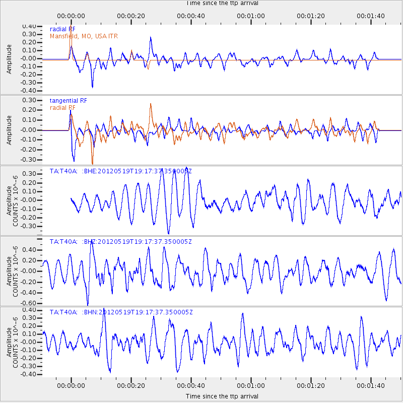
T40A Mansfield, MO, USA - Earthquake Result Viewer
*The percent match for this event was below the threshold and hence no stack was calculated.
| Earthquake location: |
Off East Coast Of Honshu, Japan |
| Earthquake latitude/longitude: |
39.7/143.3 |
| Earthquake time(UTC): |
2012/05/19 (140) 19:05:18 GMT |
| Earthquake Depth: |
10 km |
| Earthquake Magnitude: |
5.6 MB, 5.5 MS, 5.9 MW, 5.8 MW |
| Earthquake Catalog/Contributor: |
WHDF/NEIC |
|
| Network: |
TA USArray Transportable Network (new EarthScope stations) |
| Station: |
T40A Mansfield, MO, USA |
| Lat/Lon: |
37.15 N/92.52 W |
| Elevation: |
399 m |
|
| Distance: |
87.9 deg |
| Az: |
41.414 deg |
| Baz: |
320.278 deg |
| Ray Param: |
$rayparam |
*The percent match for this event was below the threshold and hence was not used in the summary stack. |
|
| Radial Match: |
61.640324 % |
| Radial Bump: |
400 |
| Transverse Match: |
58.55725 % |
| Transverse Bump: |
400 |
| SOD ConfigId: |
446234 |
| Insert Time: |
2012-08-09 01:11:20.802 +0000 |
| GWidth: |
2.5 |
| Max Bumps: |
400 |
| Tol: |
0.001 |
|
Signal To Noise
| Channel | StoN | STA | LTA |
| TA:T40A: :BHZ:20120519T19:17:37.350005Z | 1.5197549 | 1.858975E-7 | 1.2232071E-7 |
| TA:T40A: :BHN:20120519T19:17:37.350005Z | 0.6125313 | 6.142249E-8 | 1.0027649E-7 |
| TA:T40A: :BHE:20120519T19:17:37.350005Z | 2.5247786 | 2.6461365E-7 | 1.0480667E-7 |
| Arrivals |
| Ps | |
| PpPs | |
| PsPs/PpSs | |


