You are here: Home > Network List > G - GEOSCOPE Stations List
> Station NOUC Port Laguerre, New Caledonia > Earthquake Result Viewer
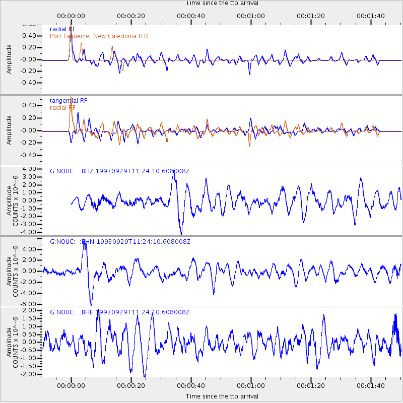
NOUC Port Laguerre, New Caledonia - Earthquake Result Viewer
*The percent match for this event was below the threshold and hence no stack was calculated.
| Earthquake location: |
Minahassa Peninsula, Sulawesi |
| Earthquake latitude/longitude: |
0.5/121.6 |
| Earthquake time(UTC): |
1993/09/29 (272) 11:16:04 GMT |
| Earthquake Depth: |
103 km |
| Earthquake Magnitude: |
6.0 MB, 6.6 UNKNOWN |
| Earthquake Catalog/Contributor: |
WHDF/NEIC |
|
| Network: |
G GEOSCOPE |
| Station: |
NOUC Port Laguerre, New Caledonia |
| Lat/Lon: |
22.10 S/166.30 E |
| Elevation: |
112 m |
|
| Distance: |
49.1 deg |
| Az: |
120.216 deg |
| Baz: |
291.293 deg |
| Ray Param: |
$rayparam |
*The percent match for this event was below the threshold and hence was not used in the summary stack. |
|
| Radial Match: |
77.73058 % |
| Radial Bump: |
326 |
| Transverse Match: |
79.712296 % |
| Transverse Bump: |
394 |
| SOD ConfigId: |
4480 |
| Insert Time: |
2010-02-26 23:38:34.365 +0000 |
| GWidth: |
2.5 |
| Max Bumps: |
400 |
| Tol: |
0.001 |
|
Signal To Noise
| Channel | StoN | STA | LTA |
| G:NOUC: :BHN:19930929T11:24:10.608008Z | 5.4624696 | 2.1607807E-6 | 3.9556846E-7 |
| G:NOUC: :BHE:19930929T11:24:10.608008Z | 1.1726663 | 3.8336216E-7 | 3.2691497E-7 |
| G:NOUC: :BHZ:19930929T11:24:10.608008Z | 3.129732 | 1.5959988E-6 | 5.099474E-7 |
| Arrivals |
| Ps | |
| PpPs | |
| PsPs/PpSs | |


