You are here: Home > Network List > TA - USArray Transportable Network (new EarthScope stations) Stations List
> Station G03D McMinnville, OR, USA > Earthquake Result Viewer
G03D McMinnville, OR, USA - Earthquake Result Viewer
| Earthquake location: |
Northern Italy |
| Earthquake latitude/longitude: |
44.9/11.2 |
| Earthquake time(UTC): |
2012/05/20 (141) 02:03:52 GMT |
| Earthquake Depth: |
6.3 km |
| Earthquake Magnitude: |
5.8 MB, 6.0 MS, 6.0 MW, 6.1 MW |
| Earthquake Catalog/Contributor: |
WHDF/NEIC |
|
| Network: |
TA USArray Transportable Network (new EarthScope stations) |
| Station: |
G03D McMinnville, OR, USA |
| Lat/Lon: |
45.21 N/123.26 W |
| Elevation: |
222 m |
|
| Distance: |
81.6 deg |
| Az: |
329.36 deg |
| Baz: |
30.83 deg |
| Ray Param: |
0.047450643 |
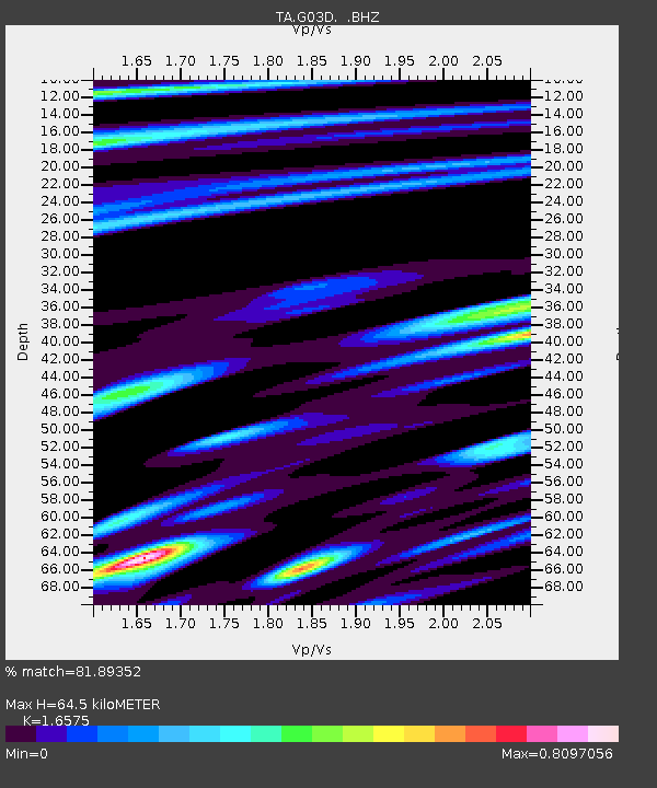
| Estimated Moho Depth: |
64.5 km |
| Estimated Crust Vp/Vs: |
1.66 |
| Assumed Crust Vp: |
6.566 km/s |
| Estimated Crust Vs: |
3.961 km/s |
| Estimated Crust Poisson's Ratio: |
0.21 |
|
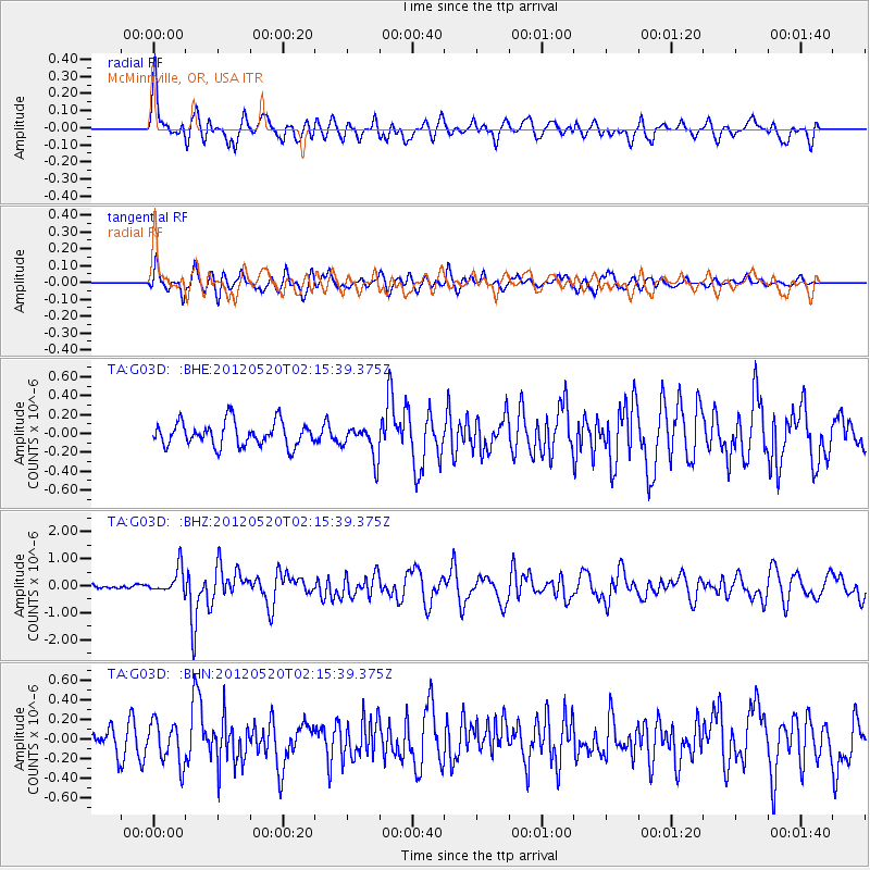
| Radial Match: |
81.89352 % |
| Radial Bump: |
400 |
| Transverse Match: |
72.80834 % |
| Transverse Bump: |
400 |
| SOD ConfigId: |
446234 |
| Insert Time: |
2012-08-25 17:23:32.171 +0000 |
| GWidth: |
2.5 |
| Max Bumps: |
400 |
| Tol: |
0.001 |
|
Signal To Noise
| Channel | StoN | STA | LTA |
| TA:G03D: :BHZ:20120520T02:15:39.375Z | 4.4037194 | 4.6500912E-7 | 1.0559463E-7 |
| TA:G03D: :BHN:20120520T02:15:39.375Z | 2.0230126 | 2.1129559E-7 | 1.04446E-7 |
| TA:G03D: :BHE:20120520T02:15:39.375Z | 1.3720847 | 1.7355012E-7 | 1.2648644E-7 |
| Arrivals |
| Ps | 6.7 SECOND |
| PpPs | 25 SECOND |
| PsPs/PpSs | 32 SECOND |


