You are here: Home > Network List > TA - USArray Transportable Network (new EarthScope stations) Stations List
> Station M38A Pleasantville, IA, USA > Earthquake Result Viewer
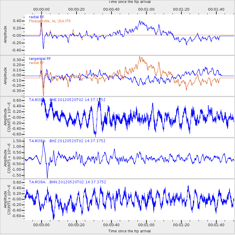
M38A Pleasantville, IA, USA - Earthquake Result Viewer
*The percent match for this event was below the threshold and hence no stack was calculated.
| Earthquake location: |
Northern Italy |
| Earthquake latitude/longitude: |
44.9/11.2 |
| Earthquake time(UTC): |
2012/05/20 (141) 02:03:52 GMT |
| Earthquake Depth: |
6.3 km |
| Earthquake Magnitude: |
5.8 MB, 6.0 MS, 6.0 MW, 6.1 MW |
| Earthquake Catalog/Contributor: |
WHDF/NEIC |
|
| Network: |
TA USArray Transportable Network (new EarthScope stations) |
| Station: |
M38A Pleasantville, IA, USA |
| Lat/Lon: |
41.42 N/93.20 W |
| Elevation: |
258 m |
|
| Distance: |
70.7 deg |
| Az: |
309.492 deg |
| Baz: |
46.833 deg |
| Ray Param: |
$rayparam |
*The percent match for this event was below the threshold and hence was not used in the summary stack. |
|
| Radial Match: |
51.007843 % |
| Radial Bump: |
400 |
| Transverse Match: |
59.29369 % |
| Transverse Bump: |
400 |
| SOD ConfigId: |
446234 |
| Insert Time: |
2012-08-25 17:32:22.663 +0000 |
| GWidth: |
2.5 |
| Max Bumps: |
400 |
| Tol: |
0.001 |
|
Signal To Noise
| Channel | StoN | STA | LTA |
| TA:M38A: :BHZ:20120520T02:14:37.375Z | 6.5546217 | 7.870847E-7 | 1.2008087E-7 |
| TA:M38A: :BHN:20120520T02:14:37.375Z | 1.6815737 | 4.091608E-7 | 2.433202E-7 |
| TA:M38A: :BHE:20120520T02:14:37.375Z | 1.751523 | 4.1285404E-7 | 2.3571144E-7 |
| Arrivals |
| Ps | |
| PpPs | |
| PsPs/PpSs | |


