You are here: Home > Network List > G - GEOSCOPE Stations List
> Station PAF Port aux Francais, Kerguelen (South Indian Ocean) > Earthquake Result Viewer
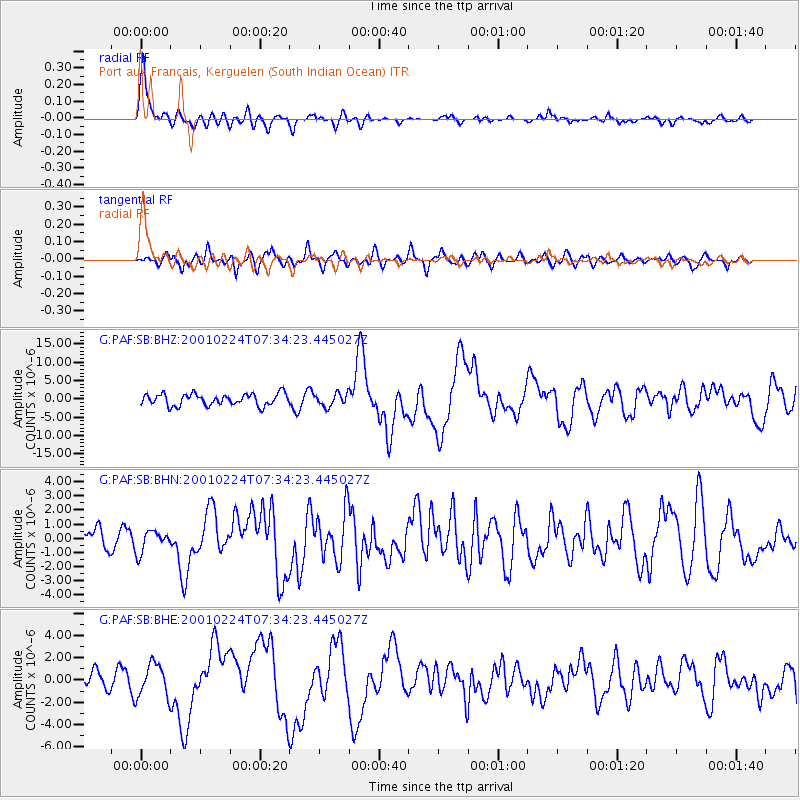
PAF Port aux Francais, Kerguelen (South Indian Ocean) - Earthquake Result Viewer

| Earthquake location: |
Northern Molucca Sea |
| Earthquake latitude/longitude: |
1.3/126.2 |
| Earthquake time(UTC): |
2001/02/24 (055) 07:23:48 GMT |
| Earthquake Depth: |
35 km |
| Earthquake Magnitude: |
6.6 MB, 7.0 MS, 7.1 MW, 7.1 ME |
| Earthquake Catalog/Contributor: |
WHDF/NEIC |
|
| Network: |
G GEOSCOPE |
| Station: |
PAF Port aux Francais, Kerguelen (South Indian Ocean) |
| Lat/Lon: |
49.35 S/70.21 E |
| Elevation: |
17 m |
|
| Distance: |
69.6 deg |
| Az: |
215.357 deg |
| Baz: |
62.212 deg |
| Ray Param: |
0.055484556 |
| Estimated Moho Depth: |
33.5 km |
| Estimated Crust Vp/Vs: |
1.83 |
| Assumed Crust Vp: |
4.73 km/s |
| Estimated Crust Vs: |
2.585 km/s |
| Estimated Crust Poisson's Ratio: |
0.29 |
|
| Radial Match: |
91.07569 % |
| Radial Bump: |
400 |
| Transverse Match: |
73.935776 % |
| Transverse Bump: |
400 |
| SOD ConfigId: |
3744 |
| Insert Time: |
2010-02-26 23:39:42.179 +0000 |
| GWidth: |
2.5 |
| Max Bumps: |
400 |
| Tol: |
0.001 |
|
Signal To Noise
| Channel | StoN | STA | LTA |
| G:PAF:SB:BHN:20010224T07:34:23.445027Z | 1.1550719 | 7.698575E-7 | 6.665018E-7 |
| G:PAF:SB:BHE:20010224T07:34:23.445027Z | 1.8058288 | 1.4712348E-6 | 8.1471444E-7 |
| G:PAF:SB:BHZ:20010224T07:34:23.445027Z | 1.1048472 | 1.7552849E-6 | 1.5887128E-6 |
| Arrivals |
| Ps | 6.0 SECOND |
| PpPs | 20 SECOND |
| PsPs/PpSs | 26 SECOND |


