You are here: Home > Network List > TA - USArray Transportable Network (new EarthScope stations) Stations List
> Station M46A Old House Field, Plymouth, IN, USA > Earthquake Result Viewer
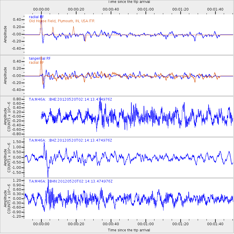
M46A Old House Field, Plymouth, IN, USA - Earthquake Result Viewer
*The percent match for this event was below the threshold and hence no stack was calculated.
| Earthquake location: |
Northern Italy |
| Earthquake latitude/longitude: |
44.9/11.2 |
| Earthquake time(UTC): |
2012/05/20 (141) 02:03:52 GMT |
| Earthquake Depth: |
6.3 km |
| Earthquake Magnitude: |
5.8 MB, 6.0 MS, 6.0 MW, 6.1 MW |
| Earthquake Catalog/Contributor: |
WHDF/NEIC |
|
| Network: |
TA USArray Transportable Network (new EarthScope stations) |
| Station: |
M46A Old House Field, Plymouth, IN, USA |
| Lat/Lon: |
41.41 N/86.35 W |
| Elevation: |
242 m |
|
| Distance: |
66.9 deg |
| Az: |
305.821 deg |
| Baz: |
50.017 deg |
| Ray Param: |
$rayparam |
*The percent match for this event was below the threshold and hence was not used in the summary stack. |
|
| Radial Match: |
67.17945 % |
| Radial Bump: |
400 |
| Transverse Match: |
64.52834 % |
| Transverse Bump: |
400 |
| SOD ConfigId: |
446234 |
| Insert Time: |
2012-08-25 17:51:29.969 +0000 |
| GWidth: |
2.5 |
| Max Bumps: |
400 |
| Tol: |
0.001 |
|
Signal To Noise
| Channel | StoN | STA | LTA |
| TA:M46A: :BHZ:20120520T02:14:13.474976Z | 3.7207658 | 7.112338E-7 | 1.9115254E-7 |
| TA:M46A: :BHN:20120520T02:14:13.474976Z | 3.2977314 | 4.7445263E-7 | 1.4387244E-7 |
| TA:M46A: :BHE:20120520T02:14:13.474976Z | 2.1915808 | 3.4326143E-7 | 1.5662734E-7 |
| Arrivals |
| Ps | |
| PpPs | |
| PsPs/PpSs | |


