You are here: Home > Network List > G - GEOSCOPE Stations List
> Station PAF Port aux Francais, Kerguelen (South Indian Ocean) > Earthquake Result Viewer
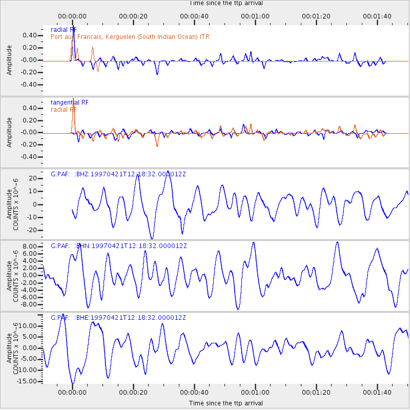
PAF Port aux Francais, Kerguelen (South Indian Ocean) - Earthquake Result Viewer

| Earthquake location: |
Santa Cruz Islands |
| Earthquake latitude/longitude: |
-12.9/166.5 |
| Earthquake time(UTC): |
1997/04/21 (111) 12:06:34 GMT |
| Earthquake Depth: |
33 km |
| Earthquake Magnitude: |
6.1 MB |
| Earthquake Catalog/Contributor: |
WHDF/NEIC |
|
| Network: |
G GEOSCOPE |
| Station: |
PAF Port aux Francais, Kerguelen (South Indian Ocean) |
| Lat/Lon: |
49.35 S/70.21 E |
| Elevation: |
17 m |
|
| Distance: |
84.4 deg |
| Az: |
220.784 deg |
| Baz: |
103.078 deg |
| Ray Param: |
0.045489796 |
| Estimated Moho Depth: |
65.75 km |
| Estimated Crust Vp/Vs: |
1.96 |
| Assumed Crust Vp: |
4.73 km/s |
| Estimated Crust Vs: |
2.41 km/s |
| Estimated Crust Poisson's Ratio: |
0.32 |
|
| Radial Match: |
80.05364 % |
| Radial Bump: |
289 |
| Transverse Match: |
62.084473 % |
| Transverse Bump: |
400 |
| SOD ConfigId: |
6273 |
| Insert Time: |
2010-02-26 23:39:50.921 +0000 |
| GWidth: |
2.5 |
| Max Bumps: |
400 |
| Tol: |
0.001 |
|
Signal To Noise
| Channel | StoN | STA | LTA |
| G:PAF: :BHN:19970421T12:18:32.000012Z | 2.05131 | 5.8559217E-6 | 2.8547229E-6 |
| G:PAF: :BHE:19970421T12:18:32.000012Z | 2.018936 | 1.0550626E-5 | 5.2258347E-6 |
| G:PAF: :BHZ:19970421T12:18:32.000012Z | 1.6614316 | 1.4930697E-5 | 8.986646E-6 |
| Arrivals |
| Ps | 14 SECOND |
| PpPs | 41 SECOND |
| PsPs/PpSs | 54 SECOND |


