You are here: Home > Network List > G - GEOSCOPE Stations List
> Station PAF Port aux Francais, Kerguelen (South Indian Ocean) > Earthquake Result Viewer
PAF Port aux Francais, Kerguelen (South Indian Ocean) - Earthquake Result Viewer
| Earthquake location: |
Flores Sea |
| Earthquake latitude/longitude: |
-7.1/122.6 |
| Earthquake time(UTC): |
1996/06/17 (169) 11:22:18 GMT |
| Earthquake Depth: |
587 km |
| Earthquake Magnitude: |
6.6 MB, 7.9 UNKNOWN, 7.8 MW |
| Earthquake Catalog/Contributor: |
WHDF/NEIC |
|
| Network: |
G GEOSCOPE |
| Station: |
PAF Port aux Francais, Kerguelen (South Indian Ocean) |
| Lat/Lon: |
49.35 S/70.21 E |
| Elevation: |
17 m |
|
| Distance: |
60.7 deg |
| Az: |
216.44 deg |
| Baz: |
64.339 deg |
| Ray Param: |
0.059043497 |
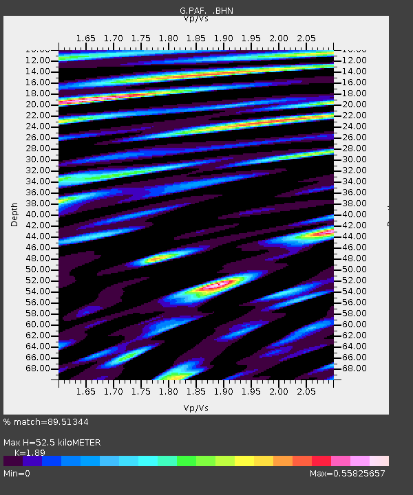
| Estimated Moho Depth: |
52.5 km |
| Estimated Crust Vp/Vs: |
1.89 |
| Assumed Crust Vp: |
4.73 km/s |
| Estimated Crust Vs: |
2.503 km/s |
| Estimated Crust Poisson's Ratio: |
0.31 |
|
| Radial Match: |
89.51344 % |
| Radial Bump: |
400 |
| Transverse Match: |
73.2916 % |
| Transverse Bump: |
400 |
| SOD ConfigId: |
4480 |
| Insert Time: |
2010-02-26 23:40:04.141 +0000 |
| GWidth: |
2.5 |
| Max Bumps: |
400 |
| Tol: |
0.001 |
|

Signal To Noise
| Channel | StoN | STA | LTA |
| G:PAF: :BHN:19960617T11:31:03.140015Z | 6.3616543 | 1.0991925E-5 | 1.7278408E-6 |
| G:PAF: :BHE:19960617T11:31:03.140015Z | 1.234689 | 1.7657887E-6 | 1.4301486E-6 |
| G:PAF: :BHZ:19960617T11:31:03.140015Z | 2.4446588 | 2.4291553E-6 | 9.936582E-7 |
| Arrivals |
| Ps | 10 SECOND |
| PpPs | 31 SECOND |
| PsPs/PpSs | 41 SECOND |


