You are here: Home > Network List > AE - Arizona Broadband Seismic Network Stations List
> Station 113A Mohawk Valley, Roll, AZ, USA > Earthquake Result Viewer
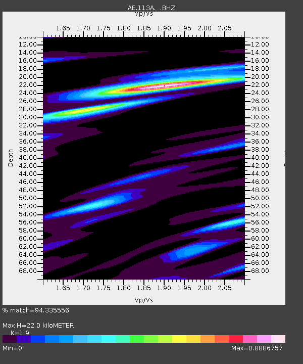
113A Mohawk Valley, Roll, AZ, USA - Earthquake Result Viewer
| Earthquake location: |
Off East Coast Of Honshu, Japan |
| Earthquake latitude/longitude: |
39.5/143.2 |
| Earthquake time(UTC): |
2012/05/20 (141) 07:19:54 GMT |
| Earthquake Depth: |
11 km |
| Earthquake Magnitude: |
5.6 MB |
| Earthquake Catalog/Contributor: |
WHDF/NEIC |
|
| Network: |
AE Arizona Broadband Seismic Network |
| Station: |
113A Mohawk Valley, Roll, AZ, USA |
| Lat/Lon: |
32.77 N/113.77 W |
| Elevation: |
118 m |
|
| Distance: |
78.7 deg |
| Az: |
56.833 deg |
| Baz: |
309.808 deg |
| Ray Param: |
0.049433894 |
| Estimated Moho Depth: |
22.0 km |
| Estimated Crust Vp/Vs: |
1.90 |
| Assumed Crust Vp: |
6.264 km/s |
| Estimated Crust Vs: |
3.297 km/s |
| Estimated Crust Poisson's Ratio: |
0.31 |
|
| Radial Match: |
94.335556 % |
| Radial Bump: |
351 |
| Transverse Match: |
76.009865 % |
| Transverse Bump: |
400 |
| SOD ConfigId: |
446234 |
| Insert Time: |
2012-08-25 18:10:29.443 +0000 |
| GWidth: |
2.5 |
| Max Bumps: |
400 |
| Tol: |
0.001 |
|

Signal To Noise
| Channel | StoN | STA | LTA |
| AE:113A: :BHZ:20120520T07:31:25.874995Z | 2.031851 | 1.4856143E-7 | 7.3116304E-8 |
| AE:113A: :BHN:20120520T07:31:25.874995Z | 1.1330401 | 6.6244816E-8 | 5.8466437E-8 |
| AE:113A: :BHE:20120520T07:31:25.874995Z | 0.7668415 | 5.0065168E-8 | 6.528751E-8 |
| Arrivals |
| Ps | 3.2 SECOND |
| PpPs | 9.9 SECOND |
| PsPs/PpSs | 13 SECOND |


