You are here: Home > Network List > G - GEOSCOPE Stations List
> Station ATD Arta Cave - Arta, Republic of Djibouti > Earthquake Result Viewer
ATD Arta Cave - Arta, Republic of Djibouti - Earthquake Result Viewer
| Earthquake location: |
Off East Coast Of Honshu, Japan |
| Earthquake latitude/longitude: |
39.5/143.2 |
| Earthquake time(UTC): |
2012/05/20 (141) 07:19:54 GMT |
| Earthquake Depth: |
11 km |
| Earthquake Magnitude: |
5.6 MB |
| Earthquake Catalog/Contributor: |
WHDF/NEIC |
|
| Network: |
G GEOSCOPE |
| Station: |
ATD Arta Cave - Arta, Republic of Djibouti |
| Lat/Lon: |
11.53 N/42.85 E |
| Elevation: |
610 m |
|
| Distance: |
90.6 deg |
| Az: |
285.414 deg |
| Baz: |
49.51 deg |
| Ray Param: |
0.041660078 |
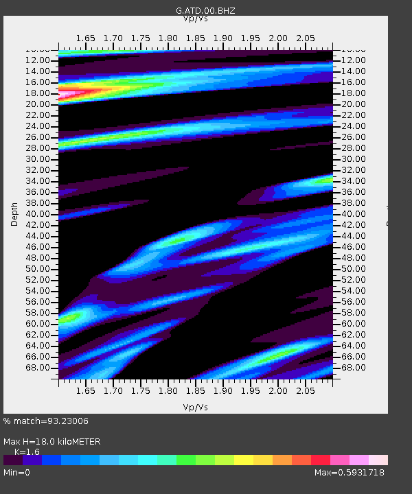
| Estimated Moho Depth: |
18.0 km |
| Estimated Crust Vp/Vs: |
1.60 |
| Assumed Crust Vp: |
6.375 km/s |
| Estimated Crust Vs: |
3.984 km/s |
| Estimated Crust Poisson's Ratio: |
0.18 |
|
| Radial Match: |
93.23006 % |
| Radial Bump: |
363 |
| Transverse Match: |
78.60145 % |
| Transverse Bump: |
400 |
| SOD ConfigId: |
446234 |
| Insert Time: |
2012-08-25 18:17:27.843 +0000 |
| GWidth: |
2.5 |
| Max Bumps: |
400 |
| Tol: |
0.001 |
|
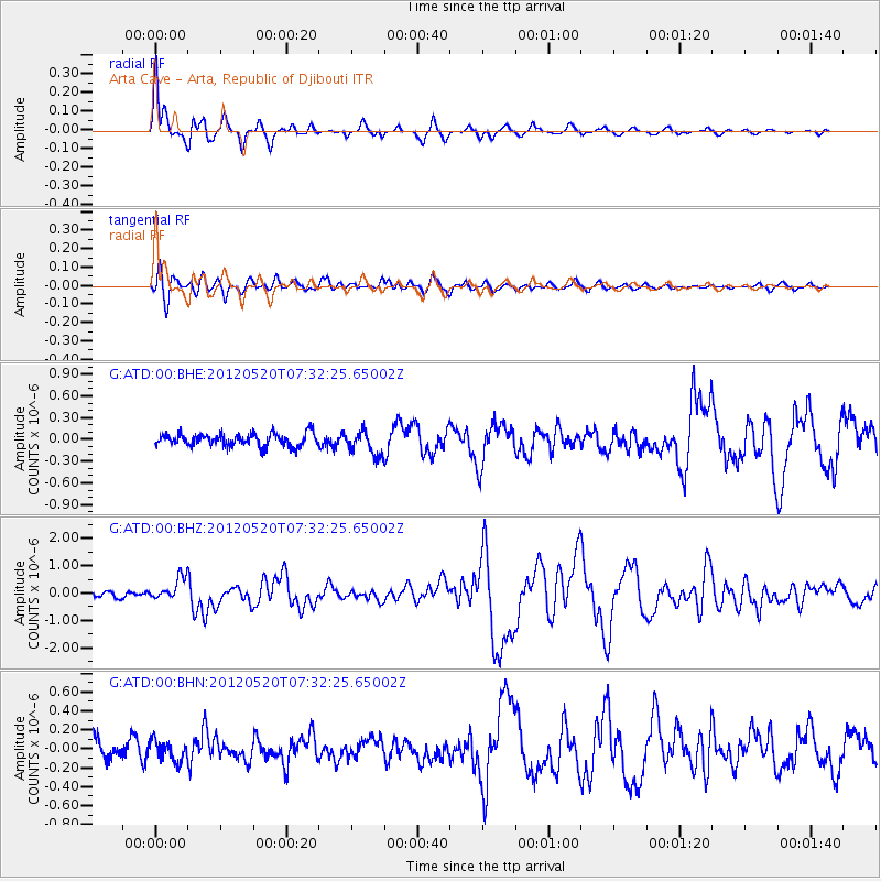
Signal To Noise
| Channel | StoN | STA | LTA |
| G:ATD:00:BHZ:20120520T07:32:25.65002Z | 4.997369 | 4.2641085E-7 | 8.532707E-8 |
| G:ATD:00:BHN:20120520T07:32:25.65002Z | 1.1757612 | 1.08319654E-7 | 9.212725E-8 |
| G:ATD:00:BHE:20120520T07:32:25.65002Z | 1.9000047 | 1.6649507E-7 | 8.762876E-8 |
| Arrivals |
| Ps | 1.7 SECOND |
| PpPs | 7.2 SECOND |
| PsPs/PpSs | 8.9 SECOND |


