You are here: Home > Network List > KZ - Kazakhstan Network Stations List
> Station ABKAR Akbulak array,AB31, Kazakhstan > Earthquake Result Viewer
ABKAR Akbulak array,AB31, Kazakhstan - Earthquake Result Viewer
| Earthquake location: |
Off East Coast Of Honshu, Japan |
| Earthquake latitude/longitude: |
39.5/143.2 |
| Earthquake time(UTC): |
2012/05/20 (141) 07:19:54 GMT |
| Earthquake Depth: |
11 km |
| Earthquake Magnitude: |
5.6 MB |
| Earthquake Catalog/Contributor: |
WHDF/NEIC |
|
| Network: |
KZ Kazakhstan Network |
| Station: |
ABKAR Akbulak array,AB31, Kazakhstan |
| Lat/Lon: |
49.26 N/59.94 E |
| Elevation: |
362 m |
|
| Distance: |
57.4 deg |
| Az: |
309.46 deg |
| Baz: |
65.657 deg |
| Ray Param: |
0.06348607 |
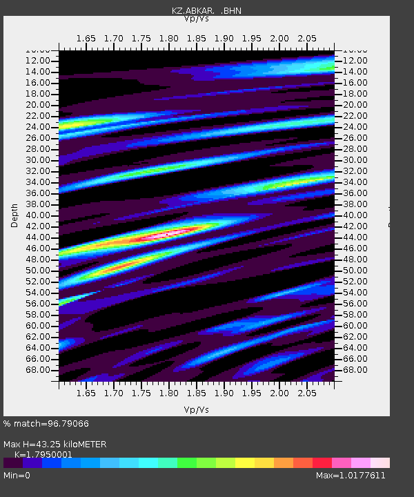
| Estimated Moho Depth: |
43.25 km |
| Estimated Crust Vp/Vs: |
1.80 |
| Assumed Crust Vp: |
6.35 km/s |
| Estimated Crust Vs: |
3.538 km/s |
| Estimated Crust Poisson's Ratio: |
0.27 |
|
| Radial Match: |
96.79066 % |
| Radial Bump: |
330 |
| Transverse Match: |
87.825584 % |
| Transverse Bump: |
400 |
| SOD ConfigId: |
446234 |
| Insert Time: |
2012-08-25 18:21:17.825 +0000 |
| GWidth: |
2.5 |
| Max Bumps: |
400 |
| Tol: |
0.001 |
|

Signal To Noise
| Channel | StoN | STA | LTA |
| KZ:ABKAR: :BHZ:20120520T07:29:12.499995Z | 34.542156 | 2.195686E-6 | 6.35654E-8 |
| KZ:ABKAR: :BHN:20120520T07:29:12.499995Z | 4.9466476 | 5.9275004E-7 | 1.1982864E-7 |
| KZ:ABKAR: :BHE:20120520T07:29:12.499995Z | 10.60662 | 1.2362907E-6 | 1.1655841E-7 |
| Arrivals |
| Ps | 5.7 SECOND |
| PpPs | 18 SECOND |
| PsPs/PpSs | 24 SECOND |


