You are here: Home > Network List > MN - MEDNET Project Stations List
> Station TIP Timpagrande, Italy > Earthquake Result Viewer
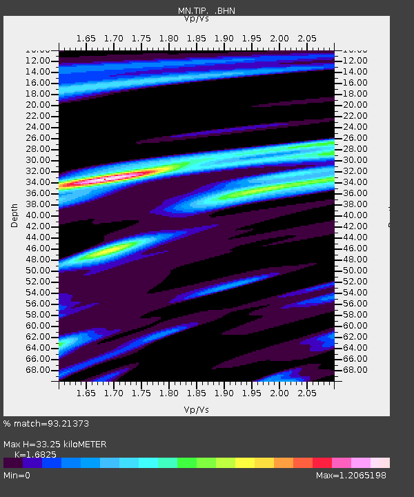
TIP Timpagrande, Italy - Earthquake Result Viewer
| Earthquake location: |
Off East Coast Of Honshu, Japan |
| Earthquake latitude/longitude: |
39.5/143.2 |
| Earthquake time(UTC): |
2012/05/20 (141) 07:19:54 GMT |
| Earthquake Depth: |
11 km |
| Earthquake Magnitude: |
5.6 MB |
| Earthquake Catalog/Contributor: |
WHDF/NEIC |
|
| Network: |
MN MEDNET Project |
| Station: |
TIP Timpagrande, Italy |
| Lat/Lon: |
39.18 N/16.76 E |
| Elevation: |
789 m |
|
| Distance: |
87.6 deg |
| Az: |
321.287 deg |
| Baz: |
38.474 deg |
| Ray Param: |
0.043198228 |
| Estimated Moho Depth: |
33.25 km |
| Estimated Crust Vp/Vs: |
1.68 |
| Assumed Crust Vp: |
6.1 km/s |
| Estimated Crust Vs: |
3.626 km/s |
| Estimated Crust Poisson's Ratio: |
0.23 |
|
| Radial Match: |
93.21373 % |
| Radial Bump: |
400 |
| Transverse Match: |
90.42655 % |
| Transverse Bump: |
400 |
| SOD ConfigId: |
446234 |
| Insert Time: |
2012-08-25 18:22:07.228 +0000 |
| GWidth: |
2.5 |
| Max Bumps: |
400 |
| Tol: |
0.001 |
|

Signal To Noise
| Channel | StoN | STA | LTA |
| MN:TIP: :BHZ:20120520T07:32:11.513972Z | 10.865312 | 5.0695627E-7 | 4.6658236E-8 |
| MN:TIP: :BHN:20120520T07:32:11.513972Z | 2.4803998 | 1.175443E-7 | 4.7389257E-8 |
| MN:TIP: :BHE:20120520T07:32:11.513972Z | 2.3741329 | 1.2377875E-7 | 5.2136404E-8 |
| Arrivals |
| Ps | 3.8 SECOND |
| PpPs | 14 SECOND |
| PsPs/PpSs | 18 SECOND |


